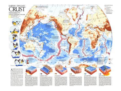
AN EXPRESSIVE FACE, Earth's surface constantly rearranges itself–at a leisurely pace but on a global scale. Internal heat seeking to escape sets continents and ocean floors in motion. The resulting earthquakes and volcanism break the crust into a patchwork of rigid plates that ride on the churning, viscous mantle below.
The continents, made of lightweight granitic rock, travel with the heavier, ever moving basaltic seafloor. The plates, made of both materials, slide away from ridges where rising heat and magma escape. The plates then sink into trenches.
Earth's great landmasses have thus glided and collided over the face of the globe for eons; some geophysicists think this movement may go back as far as four billion years. What will the future hold? Perhaps a southern California grafted onto Alaska or a new continent in the Pacific as offshore trenches fill with seamounts. Whatever its expression, a whole new face awaits dynamic Earth.
SPREADING
RISING through rifts in the crust, dense magma from Earth's interior creates new surface as the Mid-Ocean Ridge, a rugged undersea mountain range stretching 74,000 kilometers (46,000 miles). The injections widen the seafloor as much as 22 centimeters (8 inches) a year, a rate that could have formed the 7,000-kilometer-wide Atlantic in only 30 million years intead of the 165 million it has already taken. The process is not constant. The ridge itself is largely composed of short segments, each releasing irregular bursts of magma. Where the ridge runs into the northern end of the East African Rift System, the spreading action is opening a new ocean. Millions of years from now, eastern Africa may drift out into the Indian Ocean as a new continent.
SUBDUCTION
COLLIDING with the edge of a continent, old, cold, heavy seafloor dives back into the interior of the Earth and forms an ocean trench. Setting off deep-seated earthquakes, the plunging slab also generates heat that melts throught the overlying plate, allowing fingers of magma to rise. These fingers form chains of volcanoes like those of the Andes or island arcs such as the Aleutians and the Antilles. The overriding continent also compresses near the trench, lifting mountains. The destruction of ocean crust–nowhere older than 200 million years–balances creation at the ridge. Subduction can also stretch and thin the overlying plate behind the row of volcanoes, allowing magma to rise and forming a zone where a new crust and mountains are created.
COLLISION
IN THE GREATEST mountain-making process on Earth, the Indian subcontinent rams into Eurasia, creating the Himalayas. Since both continents are too light to subduct, the older, heavier Indian mass wedges under Eurasia and thrusts up the high plateaus and massive folds of the mountain range. India, once far south of the Equator, moved north in only 30 million years–a speedy trip by the geologic clock. The subcontinent contines to underthrust Asia, setting off frequent and sometimes devastating earthquakes. some 450 million years ago the collision forming the supercontinent Pangaea began to raise the 5,000-kilometer-long Appalachian and Caledonian ranges as the Atlantic Ocean's predecessor disappeared.
FAULTING
GRINDING past each other in fits and starts, the plates leave great rips, or faults, in their journey. Strain builds up along “locked” plate edges; the stress can be released gradually by thousands of tiny earthquakes or unleashed in a single disastrous jolt. Parts of California along the San Andreas Fault lurch northward as much as six meters (20 feet) during the 1906 San Francisco quake. Such transform faults also link segments of spreading centers as Earth's rigid skin adjusts to movement. These highly active fault zones form huge canyons cleaving the seafloor. As the plates move outward, the deep canyons survive as scars, or fracture zones, often thousand of kilometers long.
ACCRETION
SEAMOUNTS and other chunks of crust known as terranes pile up at trenches as the moving seafloor rafts them toward the Philippines and other island arcs. The terranes fuse to the overlying plate in jarring collisions. This accretion process could weld part of the western Pacific to Asia or Australia or even form a new continent. Most scientists gree that every continent has grown outward by accreted terranes. Alaska and most western North America were formed, patch by patch, over a span of 200 million years, with parts coming from south of the Equator. The wrenching forces of these small-scale plate collisions often fragment the terranes, dispersing their pieces in crazy-quilt fashion.
HOT SPOTS
BURNING through the crust like blasts from a flamethrower, magma floods to the surface to build massive assembly-line volcanoes like the Hawaiian Islands. Tallest mountains in the world, the islands rise 6,000 meters (19,700 feet) to the surface and as much as 4,200 meters more above the sea. A future Hawaiian island, Loihi, is still a seamount 950 meters down. Numerous strands of islands and seamounts mark the path of the plates over hot spots–each stand bent as the plates changed direction 43 million years ago. Iceland has formed within the past 55 million years as a magma plume pumps up a seemingly endless supply of rock. Yellowstone's geysers and mud pots mark North America's current position over a hot spot.