|
|
|
|
|
|
|
|
|
|
|
|
BOOKS ABOUT
THE CARIBBEAN
& WEST INDIES
|
|
|
|
|
|
|
|
|
|
|
|
|
|
|
|
|
|
|
|
|
|
|
|
|
 |
|
|
|
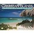
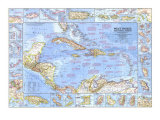
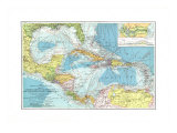
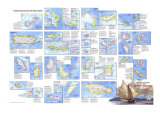
Caribbean, West Indies Posters, Charts, & Maps Index
|
geography > North America > CARIBBEAN < Hispanics and Latinos < social studies < maps
|
West Indies/Caribbean Sea Map - Wikipedia
(14º31'32"N 75º49'6"W)
|
|
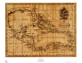
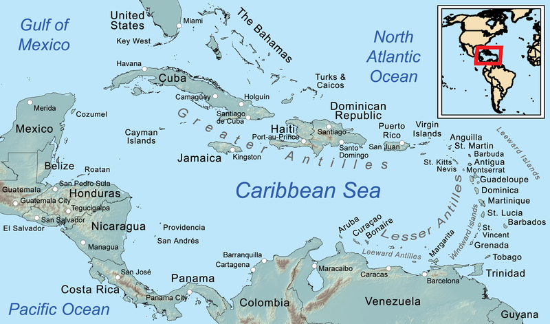
The Caribbean / West Indies is a region of the Western Hemisphere consisting of the Caribbean Sea, more than 7,000 islands, islets, reefs and cay, and the surrounding coasts located southeast of North America and the Gulf of Mexico, east of Central America, and to the north of South America.
The archipelago of the Antilles, identified as the Greater and Lesser, form the largest part of the West Indies in the Caribbean.
The “Greater Antilles” to the north and west include the larger islands of Cuba, Jamaica, Hispaniola (Haiti and the Dominican Republic), and Puerto Rico. The Greater Antilles are the highest points of the submerged North American continent.
The smaller, or “Lesser Antilles” on the southeast, — are the northerly Leeward Islands, the southeasterly Windward Islands, and the Leeward Antilles just north of Venezuela.
The Bahamas and the Turks and Caicos Islands (the Lucayan Archipelago in the Atlantic Ocean), are east of Florida and north of the Greater Antilles, are considered part of the West Indies.
|
|
|
|
|
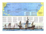
The region takes it name from the Carib, an Amerindian people who habitated the southern portion of the region and the northern coast of South America at the time Christopher Columbus was spearheading the European exploration of what they called the “New World”.
The region is also known as the West Indies because Columbus believed he had reached India when he landed on an island there in 1492, and the term “Indians” applied to the indigenous inhabitants.
The name Antilles relates back to the medieval European charts naming the lands not yet discovered Antillia - again Columbus.
(Dutch: Cariben or Caraïben; French: Caraïbe or more commonly Antilles; Spanish: Caribe)
|
|
|
|
|
|
|
|
|
|
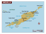
Anguilla - In 1648 France and the Netherlands agreed to joint ownership of Anguilla, a 37-square mile island, resisitng subsequent British takeover attempts. Early on, the Dutch began recovering salt from the island's lagoons for use in their herring industry. Today the island, a duty-free zone, profits from tourism. St. Barthelemy
|
|
|
|
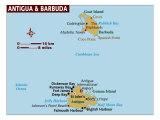
The twin-island nation of Antigua & Barbuda lies between the Caribbean Sea and the Atlantic Ocean.
|
|
|
|
|
|
|
|
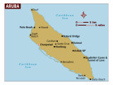
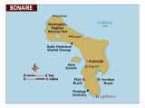
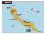
Aruba, Bonaire, and Curacao, just off the north coast of Venezuela are known as the ABCs. The islands were colonies of the Netherlands.
Netherlands Antilles is a self governing group of territories that includes Curacao, Saba, St. Eustatius and St. Martin.
In 1499 Spaniards discovered Curacao, the largest and now most populous island in the Netherland Antilles. The Dutch West India Comapy acquired the island in 1634. With its spacious, easily defended harbor, Curacao was a base for Dutch privateers before it became the headquarters for Dutch slave traffickers. Willemstad, the main town and the capital of the Netherlands Antilles, resembles Amsterdam in miniature. Oil refining caused a burst of immigration in the early 1900s, and petroleum now accounts for virtually all the Netherlands Antilles' export revenue.
St. Eustatius is an eight-square-mile volcanic islet that the French claimed in 1625 passed into Dutch hands 11 years later, serving as the principal way station and slave market for Dutch merchantment in the 17th century
|
|
|
|
Bahamas
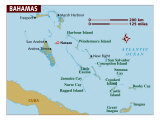
The Bahamian archipelago encompasses hundred of barren island and islets; only about 20 islands are inhabited year-round. In the 17th and 18th centuries that Bahamas offered priates ideal bases close to the mainland. Confederate blockade runners during the Civil War, liquor smugglers during Prohibition, and illicit drug traders in the 1980s – all have exploited the mazes of hidden coves and channels. Liberal tax laws encourage the presence of foreign firms and wealthy individuals. Nassau is the capital city of the Bahamas.
|
|
|
|
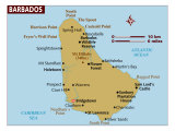
Barbados – Settled by the English in 1627, more than 250,000 people now live in city-like concentrations on Little England, as this 166-square-mile agriculturally based island is known. Dutch sugar planters arrived from Brazil around the mid-17th century, and soon Barbados and sugar were synonymous. Long one the richest of Britain's West Indian colonies, Barbados won independence in 1966.
|
|
|
|
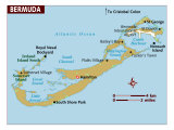
Bermuda, on the same latitude as Savannah, Georgia, are not part of the Caribbean Sea. They are the world's most northernmost coral islands where more than half a million visitors a year help provide this self-governing British colony with the highest per capita income of the islands. Bermuda enjoys a mild year-round climate, thanks to the warming influence of the Gulf Stream. Hamilton is the capital of Bermuda.
|
|
|
|
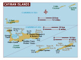
Grand Cayman is the largest of the three Cayman Islands. The Cayman's have a healthy economy based on tourism, banking and tax-free investment opportunities.
|
|
|
|
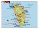
Dominica – Fierce Carib Indians and a French presence kept the British from colonizing this mountainous, forested island until the mid-18th century. Bananas are the major export crop, but other products include vanilla, coconuts, coffee, limes and soap. Dominica declared independence from Britain in 1978.
|
|
|
|
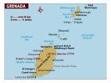
Grenada – A densely populated island, Grenada produces nutmeg, mace – an aromatic by-product of nutmeg – cacao, and bananas. Five years after independence from Britain in 1974, revolutionaries seized power. In 1983 a U.S.-orchestrated invasion ousted Grenada's Marxist regime.
|
|
|
|
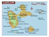
Guadeloupe – Grande-Terre and Basse-Terre form the heart of the French overseas department of Guadeloupe. French colonization began in 1635, and by mid-century Dutch refugees from Portuguese Brazil had helped introduce sugar on a commercial basis. After emancipation in 1848, sugar gave way to bananas, which could be produced by a much smaller labor force.
|
|
|
Hispaniola -
|
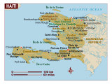
Haiti – France's richest slave-based colony won independence in 1804 after 12 years of struggle. Violence continued to wrack Haiti, which the U.S. occupied from 1915 to 1934. Three decades of despotic rule by the Duvalier family ended in 1986, when Jean-Claude Duvalier fled to France. Port-au-Prince is the capital of Haiti.
|
|
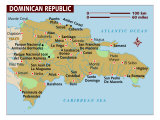
Dominican Republic - Ruled first by Spain, then France, and finally Haiti, the eastern portion of Hispaniola gained independence as the Dominican Republic in 1844. The 20th century was turbulent; U.S. troops occupied the country between 1916 and 1924 and again in 1965 and 1966 during the civil war that followed the assassination of dictator Trujillo. Despite the economic benefits of tourism, poverty and illiteracy beset this nation of six million people. The capital of the Dominican Republic is Santo Domingo.
|
|
|
|
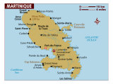
Martinique - Mount Pelee, whose catastrophic eruption in 1902 killed some 30,000 people, dominates Martinique. Frenchmen from St. Christopher (St. Kitts) settled Martinique in 1835, and the sugar-rich island was later made capital of the French West Indies. In 1946 Martiniques became a French overseas department. The mainly black population speaks a Creole patois.
|
|
|
|
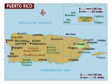
Puerto Rico - In 1508 Juan Ponce de Leon found a settlement on Puerto Rico. Sir Francis Drake's fleet attacked the fortress of San Felipe del Morro in 1595, the Dutch laid siege in 1625, the British ships blasted the bastion in 1797. The city of San Juan ballooned after World War II, and, with more than 1.5 million people, metropolitan San Juan now encompasses on the Middle America's largest industrial complexes.
Ponce, laid out in 1692, is a focal point on the south coast. Coffee growing spread into the southern interior in the 19th century, and this accessible port grew as an exporting center. Today Ponce ships sugar and sum and produces cement, textiles, footwear and paper products.
|
|
|
|
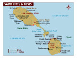
St. Christopher (St. Kitts) and Nevis – The English and French shared St. Christopher with France 1623-1714. In the mid-1600s sugar planters had fanned out from this “mother colony” of the Less Antilles in search of arable land. Today sugar is still king, but tourists are discovering the islands. Nevis produces coconuts and sea island cotton.
|
|
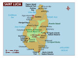
St. Lucia – By 1814, when Britain acquired St. Lucia permanently from France, the native Caribs had died out. During the 1800s the island was a major coal-bunkering point in the West Indies; it was a U.S. lend-lease base in World War II. Recent efforts to reduce dependence of agriculture – particularly bananas – include the creation of a free-trade zone, the promotion of tourism, and the building of industrial estates and an oil transhipment terminal.
|
|
|
|
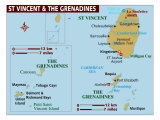
St. Vincent and the Grenadines – British occupation, beginning 1763, was fiercely resisted by Black Caribs, descendants of escaped slaves and Carib Indians. By the 1800s most had been deported to Central America. A Mount Soufriere eruption killed more than 2,000 islanders in 1902, and in 1979 the transition of this poor British territory to independent nation was set back by another eruption. St. Vincent produces about half of the owrld's arrowroot, a food-thickening starch.
|
|
|
|
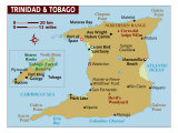
Trinidad and Tobago – Christopher Columbus discovered Trinidad in 1498; Spaniards settled the island in 1532. French, Dutch, and English buccaneers raided repeatedly in the 1600s, and British occupation began in 1797. After the emancipation of slaves in 1834, sugar planters imported Hindu and Muslim laborers. Petroleum, asphalt, chemicals – and increasingly tourism – underpin the modern ecomony.
|
|
|
|
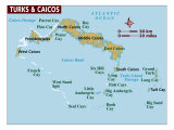
Turks & Caicos Islands – During the 17th century French, English, and Dutch pirates, whose raids debilitated Spanish fleets, made this barren island their headquarters. In 1697 Spain ceded Tortuga and western Hispaniola to France. Having achieved its goal of acquiring a piece of Spanish territory, France moved quickly to stamp out buccaneering from Tortuga.
|
|
|
|
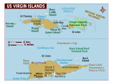
Virgin Islands archipelago covers some 200 square miles. The Netherlands, France, England, Spain, Denmark – which eventually won control over the western two-thirds of the group – and even the Knights of Malta owned various islands for a time. Recognizing the strategic potential of the harbor at Charlotte Amalie on St. Thomas, the U.S. Purchased the Danish Virgin Islands in 1917. Since World War II, federal subsidies, small-scale manufacturing, and tourism have enriched the U.S. territory. The British Virgin Islands depend on fishing and farming.
|
|
|
|
Caribbean Islands of Cuba, Bahamas, Cayman, Jamaica and Haiti
|
|
|
|
|
|
|
|
|
|
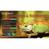
Biosphere: Adaptations & Biodiversity
Poster Text: An adaption is a change in the structure or function of an organism which allows it to thrive within its environment. It may take physical adaptation such as the size or shape of the organism or it way in whch its body works. It may also be a change in an animals behavior. Adaptation is produced through the process of natural selection. As the environment changes, organisms that cannot adapt eventually die. Individuals with the ability to adapt produce more successful offspring. These offspring may carry the adaption forward until the whole species contains organisms which are adapted to the new environment.
An organism's environment consists of many important element whcih can influence adaption. Whether the climate is hot, cold, dry or wet will have an effect on all creatures that live in that environment. The presence of predators will also have an effect. Prey animals must learn to defend themselves or become adept at escaping predators.
• more Eco-sphere posters
• Biodiversity in Belize
|
|
|
previous page | top
geography > North America > CARIBBEAN < Hispanics and Latinos < social studies
|
|
I have searched the web for visual, text, and manipulative curriculum support materials - teaching posters, art prints, maps, charts, calendars, books and educational toys featuring famous people, places and events - to help teachers optimize their valuable time and budget.
Browsing the subject areas at NetPosterWorks.com is a learning experience where educators can plan context rich environments while comparing prices, special discounts, framing options and shipping from educational resources.
Thank you for starting your search for inspirational, motivational, and educational posters and learning materials at NetPosterWorks.com. If you need help please contact us.
|
|
|