|
|
|
|
|
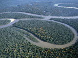
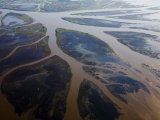
Amazon River, the largest river in the world by volume (total river flow is greater than the next top eight largest rivers combined), also has the largest drainage system.
The Amazon is not crossed by bridges because the surrounding tropical rainforest is not heavily populated.
FYI ~ Explorer and conquistador Francisco de Orelanna completed the first navigation of the length of the river (1541-42) which was known as Rio Grande, Rio Santa Marie de la Mar Dulce or Rio de Canela (Cinnamon) in search of gold. The name Amazon perhaps refers to the fierce Indians along the river, reminding Orelanna of the Scythian female warriors of Greek mythology.
• Chico Mendes
• Amazon Sweet Sea: Land, Life & Water at the River's Mouth
• South America posters
|
|
|
|
Amur River, the world's ninth longest river, forms the border between the Russian Far East and Northeastern China.
|
|
|
|
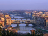
The Arno, a river in the Tuscany region of Italy, flows from the Apennines through Florence and Pisa, into the Ligurian Sea, an arm of the Mediterranean Sea. A 1966 Arno flood damaged or destroyed many works of art in Florence.
FYI - The Medieval architect Taddeo Gaddi is generally considered to be the designer of the Ponte Vecchio bridge which was not destroyed in World War II by the retreating Germans in 1944, allegedly because Hilter expressly forbade its destruction.
Supposedly the term bankrupt originated on the Ponte Vecchio over the Arno - when a merchant could no longer pay his debts, his banca, or table, was smashed, "rotto", for “banca rotta”.
|
|
|
|
Atchafalaya River, a distributary of the Mississippi and Red Rivers in south central Louisiana, is now forming a new delta in the Gulf of Mexico, the only place on the Louisiana coastline that is gaining ground. The river valley forms the Atchafalaya Basin and Atchafalaya Swamp.
The name “Atchafalaya” is from the Choctaw for “long river”.
|
|
|
|
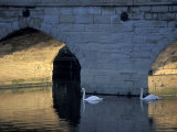
The Avon (Warwickshire*) is memorialized by William Shakespeare as the “Bard of Avon”.
The word avon is derived from abona, and early English word for “river”, so Avon River is really “River River”.
BTW - there is more than one Avon River in England. The “Bristol” Avon flows through the city of Bath.
|
|
|
|
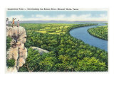
The Brazos River is the longest river in the U.S. state of Texas.
The early Spanish explorers called it Rio de los Brazos de Dios, “The River of the Arms of God”.
|
|
|
|
previous page | top | next
rivers | A-B | c | d | e-f-g-h-i-j | k-l | m | n | o | p | q-r | s | t-u-v | w-x-y-z
|
|
I have searched the web for visual, text, and manipulative curriculum support materials - teaching posters, art prints, maps, charts, calendars, books and educational toys featuring famous people, places and events - to help teachers optimize their valuable time and budget.
Browsing the subject areas at NetPosterWorks.com is a learning experience where educators can plan context rich environments while comparing prices, special discounts, framing options and shipping from educational resources.
Thank you for starting your search for inspirational, motivational, and educational posters and learning materials at NetPosterWorks.com. If you need help please contact us.
|
|
|