|
|
|
|
|
|
|
|
|
|
|
|
|
|
|
|
|
BOOKS ABOUT AFRICA & MADAGASCAR
|
|
|
|
|
|
|
|
|
|
|
|
|
|
|
|
|
|
|
|
|
|
|
|
|
 |
|
|
|
|
|
|
|
|
|
|
Madagascar Posters, Art Prints, Charts, Maps
for the geography and social studies classrooms, and theme decor for office or studio.
|
geography > Africa > MADAGASCAR < social studies
|
|

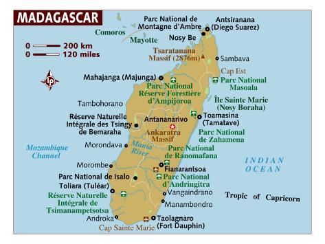
Madagascar Map
(20º0'0"S 47º0'0"E)
|
|
The Republic of Madagascar is in the Indian Ocean, east of Mozambique on the mainland of Africa. The island, the fourth largest in the world, has mountains and high plateau in the center with a narrow coastal plain.
Several species of flora and fauna unique to Madagascar are endangered with soil erosion resulting from deforestation and overgrazing, desertification and water pollution.
|
|
|
|
|
|
Antananarivo, the capital and largest city in Madagascar, was founded circa 1625 by King Andrianjaka.
The name Antananarivo means “the City of the Thousand”, describing the number of soldiers assigned to guard it.
|
|
|
|
|
|
|
|
|
|
|
|
|
|
|
|
|
|
|
|
|
previous page | top
|
|
I have searched the web for visual, text, and manipulative curriculum support materials - teaching posters, art prints, maps, charts, calendars, books and educational toys featuring famous people, places and events - to help teachers optimize their valuable time and budget.
Browsing the subject areas at NetPosterWorks.com is a learning experience where educators can plan context rich environments while comparing prices, special discounts, framing options and shipping from educational resources.
Thank you for starting your search for inspirational, motivational, and educational posters and learning materials at NetPosterWorks.com. If you need help please contact us.
|
|
|
