|
|
|
|
|
|
|
|
|
|
|
|
BOOKS ABOUT AFRICA & TUNISIA
|
|
|
|
|
|
|
|
|
|
|
|
|
|
|
|
|
|
|
|
|
|
|
|
|
|
|
|
|
|
|
|
|
 |
|
|
|
|
|
Tunisia Posters, Art Prints, Charts, Maps
& curriculum enrichment resources for social studies classrooms and homeschoolers.
|
geography > Africa > TUNISIA < Middle East < social studies
|
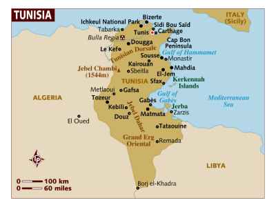
The Republic of Tunisia is on the northern Mediterranean coast of Africa between Libya to the south and east, and Algeria to the west. The distance from Tunis/Carthage to the Italian island of Sicily is just under 200 miles.
While the Sahara Desert is the landscape most associated with Tunisia, there is also a Mediterranean climate along the coast with fertile land that has been farmed for millinenia. The capital of Tunisia is Tunis, which is located on the Gulf of Tunis.
Earliest inhabitants of the area were the Berber nomads. The Phoenicians settled on the coast c. 10th century BC, with Carthage, founded by Queen Dido, after becoming the the dominate power of the Mediterranean by defeating the Greeks.
Rome eventually conquered Carthage in the 2nd century BC after a series of wars that included Hannibal's march with war elephants from Iberia, over the Pyrenees and Alps to northern Italy.
Tunisia was conquered by Arab Muslims in the 7th century AD, after being held by both the Vandals and Byzantines. Tunisia was the first Mediterranean country to sign an associate agreement with the European Union (EU).
|
|
|
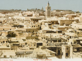
Tunis, the capital and largest city of the north African nation of Tunisia, is located on the Gulf of Tunis of the Mediterranean Sea.
The ancient city of Carthage is today a suburb of Tunis.
Notable people associated with Tunis: Ibn Khaldun.
|
|
|
|
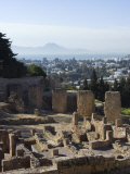
The Phoenicians, who dominated Mediterranean with their ships and trading after defeating the Greeks, settled on the Tunisian coast c. 10th century BC.
Carthage, which means “new town”, was founded by Queen Dido, a refugee from her brother in Tyre (today's Lebanon); Carthage was a separate political entity from other Phoenician settlements.
The Carthaginian invasion of Italy by Hannibal, who took war elephants from northern Africa through the Iberian peninsula and over the Alps, was one of the wars that stymied Rome, though Rome eventually conquered Carthage.
Did you know? - the name Hannibal means 'Ba'al is my grace'? The original Semetic meaning of ba'al is "master” or "lord"; the word ba'al in Engish generally refers to false gods.
|
|
|
|
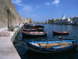
Bizerte, in addition to being the oldest and most European city in Libya, is also the northernmost city in Africa.
|
|
|
|
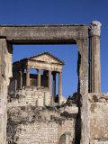
Thugga, today's Dougga, a UNESCO World Heritage site, is the best preserved Roman small town in Tunisia. The elevated site overlooks a rich agricultural area, valued as a "bread basket" since antiquity.
|
|
|
|
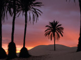
The Sahara Desert composes 40% of Tunisia. The town of Douz is known as the "gateway to the Sahara" and historically was a producer of dates as well as a stop on the trans-Saharan caravan routes.
The Sahara Festival is an annual celebration of traditional ways and culture.
|
|
|
|
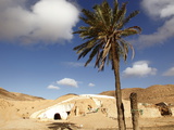
The name troglodyte, “cave dwellers”, were people mentioned by many ancient geographers and historians from Greece and Rome. Here the word is used to describe the ancient pit homes revealed in 1967 when unusually heavy rains flooded the area.
FYI - the area was used as sets in the first Star Wars movie.
|
|
|
|
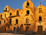
Ksar, a word possibily evolved from the Latin castrum for castle, is generally an attached group of houses that have collective granaries, ovens, baths, shops, even mosques, built within a continous wall.
The location of Ouled Soltane was also used in the Star Wars: The Phantom Menace.
• food posters
|
|
|
|
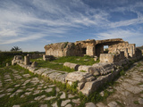
Bulla Regia, an archaeological site in northwestern Tunisia, is noted for its semi-subterranean housing.
Temperature was controlled by having a ground-level, which would gather warmth from winter sun, above underground rooms that were built around a two-story atrium. The open-bottomed terracotta bottle-shapes that were built into vaulting for air circulation, and the water sprinkled on the mosiac floors that evaporated provided cooling during the summer.
• see biomimicry
|
|
|
|
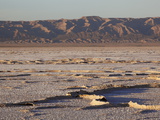
Chott El Jerid is the largest salt pan in the Sahara. Summer crossing by foot or car are dangerous due to the possibility of a weak crust; in winter it might be crossed by boat.
• lakes posters
|
|
|
|
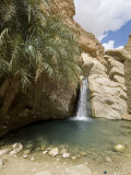
An oasis is an isolated area of vegetation in a desert, usually surrounding a spring or other water source.
The mountain oasis at Cheika was the site of several movies: Star Wars IV: A New Hope, and The English Patient.
|
|
|
|
|
|
previous page | top
|
|
I have searched the web for visual, text, and manipulative curriculum support materials - teaching posters, art prints, maps, charts, calendars, books and educational toys featuring famous people, places and events - to help teachers optimize their valuable time and budget.
Browsing the subject areas at NetPosterWorks.com is a learning experience where educators can plan context rich environments while comparing prices, special discounts, framing options and shipping from educational resources.
Thank you for starting your search for inspirational, motivational, and educational posters and learning materials at NetPosterWorks.com. If you need help please contact us.
|
|
|


![Punic coin bearing the head of Hamilcar Barca [Hannibal] (c.270-228 BC) minted at Carthage, c.230 BC, Giclee Print](http://imagecache2.allposters.com/images/BRGPOD/84249_a.jpg)