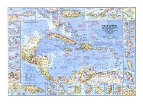
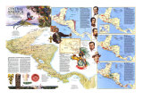
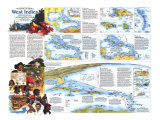
CHRISTOPHER COLUMBUS - In his forty-first year, Christopher Columbus sailed westward from Palos de la Frontera, Spain, in search of a trade route to Asia. When he discovered the Bahamas, he thought he had reached coastal islands near the Asian mainland. Over the next 11 years he made three more voyages, primarily in search of gold, and never realized the true nature of his discoveries. until his death in 1506, he continued to appeal to King Ferdinand for the titles and revenues Spain had promised him. -
Columbus made his first New World landfall in the Bahamas on October 12, 1492, after 36 days at sea. The island, long called Watling, was rechristened San Salvador in 1926, the name Columbus originally gave it. *UPDATE reported on 1987 NG map - recent research reveals that Christopher Columbus is most likely to have made his first landfall in the New World at Samana Cay, which lies some 60 mautical miles northwest of Samana Cay.
With his discovery of Cuba on October 27, 1492, Columbus believed had reached Asia and dispatched envoys to find the Emperor of China.
Columbus lost his flagship, Santa Maria, on Hispaniola, Christmas Eve, 1492. The stranded crew built La Navidad, the first European settlement in the New World. On Columbus's return in 1493, the village had disappeared, presumably wiped out by Indians.
During his third voyage to the New World, Columbus sighted South America on August 1, 1498. A few days later he became the first European to set foot on that continent.
SPACE FLIGHT SPLASHDOWNS - The Atlantic missile range has served as a primary landing area for the United States manned space program. Splashdown sites shown on the map:
Freedom 7 - May 5, 1961 - Shepard, First U.S. space flight
Friendship 7 - Feb.20, 1962 - Astronaut John Glenn, First U.S. orbital flight
Aurora 7 - May 24, 1962 - Carpenter
Gemini 3 - March 23, 1965 - Grissom and Young
Gemini 6, Dec. 16, 1965 - Schirra and Stafford
Gemini 7, Dec 18, 1965 - Borman and Lovell
Gemini 11, Sept. 15, 1966 - Conrad and Gordon
Gemini 12, Nov. 15, 1966 - Lovell and Aldrin
Apollo 9, March 13, 1969 - McDivitt, Scott, Schweickart
In addition to the landing sites shown on the map, the following flights splashed own in the target area but just off this map to the north: Liberty Bell 7, Astronaut Grissom; Gemini 4, Astronauts McDivitt and White; Gemini 5, Astronauts Cooper and Conrad; Gemini 9, Astronauts Stafford and Cernan; and Apollo7, Astronauts Shirra, Eisele, and Cunningham. Other space flights landed in the Pacific.
WEST INDIES ASSOCIATED STATES - Established in February 1967, the Associated States now include the former British island Colonies of Antigua, Dominica, St. Lucia, Grenada, St. Vincent, and St. Christopher-Nevis. Anguilla was a member of this last state until July 1967, when it unilateraliy withdrew. The states are autonomous and individually associated with the United Kingdom which is responsible for the defense and foreign affairs of each.
HURRICANES - An average of seven hurricanes a year develop near the Lesser Antilles between June and October, generally moving first toward the northwest, later, veering to the north.
NEW WORLD NAMED FOR ITALIAN NAVIGATOR - Alonso de Ojed and Amerigo Vespucci explored Venezuela's coast in 1499. Amerigo's account of this voyage ultimately led to both continents be named America.
NETHERLAND ANTILLES - ... consist of the islands of Aruba, Curacao, and Bonaire of Venezuela's coast, and Saba, St. Eustatius, and southern St. Martin in eh Leeward Islands.
NATIVES OF THE WEST INDIES - Recent archeological evidence indicates the Ciboneys, a fishing people, spread from Venezuela to the West Indies before 3500 B.C. later, between the 1st and 11th centuries A.C., the agricultural Arawaks followed them to the islands, gradually absorbing the Ciboney population. Shortly before Columbus's first voyage, warlike Caribs drove the Arawaks from the Lesser Antilles. Under the Europeans, the Arawaks and Ciboneys became extinct by 1600; the Caribs resisted colonization for 200 years more before makng peace with the British. Today only a few hundred Caribs survive in a reserve on the island of Dominica.
TREASURE GALLEONS - During the colonization of the New World, billions of dollars worth of gold, silver, and jewels were loaded aboard ships, mostly Spansh treasure galleons, bound for Europe. An estivated 25 percent of this wealth sank in transit, much of it in the Caribbean shallows. Some of the sunken treasures still invite adventurous divers.
PIRACY - Pirates and privateers found shelter in the leeward lagoons and harbors of the Caribbean's numerous islands. From the 16th century through the 18th, cargo-laden merchant ships and rich coastal ports lived in fear of “El Draco”–Drake–Morgan, Blackbeard, and their like.
Port Royal, known as “Jamaica's buccaneer captial,” was struck by a devastating earthquake on June 7, 1692. Two-thirds of the city slid into the Caribbean, and 2,000 people perished. ---
SLAVERY - Soon after Columbus's landings, the Spanish began to enslave island natives. By 1502, they were importing Africans to Hispaniola, and shortly afterward slave ships began regular passages between Africa and the West Indies. In 1834 the British abolished slavery, followed by the French, Danish, Dutch, and Spanish. In Cuba, slavery existe until 1886.
TREATY DIVIDES NEW WORLD - Spain and Portugal signed the Treaty of Tordesillas in 1494, dividing the recently discovered New World along a line near 47 degrees west longitude. Lands west of the demarcation became Spain's dominion; those to the east, Portugal's. Under thise terms, Spain owned nearly the whole of the two continents, while Portugal could claim only Brazil.
GULF STREAM -The Guld Stream is a warm ocean current created by the flow of water from the Caribbean Sea through the Yucatan Channel. Equivalent in volume to 1,000 Mississippi Rivers, it tempers climate as it course along the coast of North America and on to northern Europe.
In the early morning hours of May 8, 1902, Mont Pelee erupted (Martinique). In less than three minutes it annihilated the city of St. Pierre with a cloud of superheated steam and ash, leaving all but one of the 30,000 inhabitants dead.
The commonwealth of Puerto Rico is a free state associated with the United States by virtue of a bilateral compact, which was ratifed by the island's people and the Congress of the United States. Puerto Rico's constitution was proclaimed July 25, 1952.