SOCIAL STUDIES-

20th Century America
American Experience
American Revolution
Colonial America
Founding Fathers
Ancient Civilizations
Anc. African Civilizations
anthropology
Asian Americans
aviation
banned books/authors
Bill of Rights
Black History
US Civil War
Voices of Diversity
notable educators
explorers
flags
geography
Great Thinker Quotes
Heroes Science & Tech
Heroes from History
notable historians
Historic Days
historic documents
Historic Headlines
Historic Heroes
history of art
History Through Lens
History Through Literature
Holocaust
Images of Labor
Inventions Changed World
Latinos
maps
Middle Ages
money/currency
Nation of Immigrants
Native Americans
Olympics
peace & justice
philosophers
Political Leaders- US
Political Process
presidents
Stonehenge
Supreme Court
Supreme Court Justices
Technology's Past
Vietnam Era
world leaders
world's religions
World War I
World War II
This Day in History


CALENDARS

Global Wonders Calendars


SOCIAL STUDIES READING

Essentials of Elementary Social Studies
Essentials of Elementary
Social Studies

Social Studies Activities Kids Can't Resist
Social Studies Activities
Kids Can't
Resist

Teaching Reading in Social Studies, Science & Math
Teaching Reading
in Social Studies,
Science & Math

Social Studies & Citizenship Education

Big Book of Reproducible Graphic Organizers

Social Studies & the Young Learner
Social Studies &
the Young Learner


Social Studies
Links for Learning


Teacher's Best - The Creative Process


National Geographic Maps
for Social Studies, Humanities & Science Education Classroom and home schoolers.


history > social studies > maps > NATIONAL GEOGRAPHIC MAPS INDEX < geography


Pacific Ocean Floor Art Print
Pacific Ocean Floor
Wall Mural details
Atlantic Ocean Floor 1990 Wall Mural
Atlantic Ocean Floor
Wall Mural details
Arctic Ocean Floor Giclee Print
Arctic Ocean Floor
Giclee Print
Indian Ocean Floor, Giclee Print
Mediterranean Seafloor Map Poster
Antarctica Satellite Map Poster

Peoples of South Asia Map, 1984
India Map Poster, 1997
Historical Japan Map Poster, 1984

Peoples of the Middle East Poster
Middle East People
first published as a double sided poster in 1972, details
more Middle East poster maps

ANTHROPOLOGY
Peoples of South Asia Map, 1984
Peoples of Southeast Asia Map, 1971
Peoples of Southeast Asia Map, 1984
Peoples of South Asia Map, 1984
Peoples of Arctic Map, 1983
Peoples of the Soviet Union Map, 1976
Peoples of the Soviet Union Poster Map (1976)

Russia posters

China Poster Map, 1999, side 2
China Poster Map,
1999, side 2
Peoples of China Poster Map (1980)
Peoples of China
Poster Map (1980)

China posters

Pacific Rim Map Poster, 1989
Western Pacific Rim
Map Poster, 1989
Indonesia Map, 1996 Side 2
Indonesia
Poster Map, 1996
Side 2
Discovers of the Pacific Map Poster, 1974
Dawn of Humans Map Poster, 1997

Native American Heritage Map 1991, Giclee Prin
Native American Heritage
Map 1991, Giclee Print

more Native American posters

American Indian Cultures Poster Map
American Indian Cultures
Poster Map

anthropology posters

Archaeology of South America Map, 1982, Poster

Indians of South America Map 1982, Poster

Africa Political Map, Art Print
Africa Political Map,
Art Print

Africa, Its Political Development Map 1980, Giclee Print
Africa, Its Political Development Map 1980,
Giclee Print

Heritage of Africa Map 1971, Giclee Print

Ethnolinguistic Map of the Peoples of Africa Map 1971, Giclee Print

Map of the Suez Canal, Art Print
Map of the Suez Canal,
Art Print

A Map of Africa to Illustrate the Travels of David Livingstone, Giclee Print
A Map of Africa
Illustrating the Travels
of David Livingstone,
Giclee Print

maps posters
Earth from Space posters
explorers posters

Land of the Maya Map Poster, 1989

Ancient Maya World Map 1989, Giclee Printt
Ancient Maya
World Map,
Giclee Printt

Travelers Map of Mexico Poster, 1994

Visitors Guide to the Aztec World Map Poster, 1980
Visitors Guide to the
Aztec World Map Poster, 1980

Archeological Map of Middle America, Land of the Feathered Serpent, Print
Archeological Map of Middle America, Land of the Feathered Serpent, Poster

Archeological Map of Middle America, Land of the Feathered Serpent, Poster, side 2

Central America Map Poster, 1986 Political

Central America Map Poster, 1986, History

Central America & West Indies Map Poster, 1970
Central America &
West Indies Map Poster, 1970

West Indies Map Poster, 1987, side 2
West Indies Map
Poster, 1987, side 2

Tourist Islands of the West Indies Map 1981, Giclee Print

Where Did Columbus Discover America? Map Poster


New England Map Poster, 1987, side 2

New England Map Poster, 1987, Side 1

New England Map Poster, 1987, side 2
Northeast USA Map Poster, 1978, Glittering Cities, Lonely Wild Lands

Western New England Map Poster, 1975, Mountains, Seacoast and a Living Legacy

Atlantic Gateway Map Poster, 1983, side 2

Maine Map Poster, 1975, Sea-swept Coves Beside a Forested Realm

Mid Atlantic States Map Poster, 1976, Beckoning Land Beside Bay and Sea

Northern Approaches- Maine to the Maritimes Map Poster, 1985, side 2

Shipwrecks of Delmarva Map Poster
Shipwrecks of Delmarva
Map Poster

Tidewater and Environs Map Poster, 1988, side 2

Shipwrecks of the Northeast Map Poster

Ghost Fleets of the Outerbanks Map Poster

North Central States Map Poster, 1974, Open Skies and Rolling Land

Great Lakes Poster Map, 1987, side 2
Great Lakes Poster Map,
1987, side 2

Northern Plains Map Poster, 1986, side 2
Northern Plains Map Poster,
1986, side 2

Wisconsin, Michigan, and The Great Lakes Poster Map, 1973, Land Between the Waters

Central Plains Map Poster, 1985, side 2
Central Plains Map Poster,
1985, side 2

Ohio Valley Map Poster, 1985, side 2
Ohio Valley Map Poster,
1985, side 2

Prairie Provinces Map Poster, 1994, side 2
xPrairie Provinces Map Poster, 1994, side 2

South Central States Map Poster, 1974, Rich Land of the Southern Frontier

Deep South Map Poster, 1983, side 2
Deep South Map Poster,
1983, side 2


ANIMALS

North America in the Age of Dinosaurs Poster
North America in the
Age of Dinosaurs Poster

dinosaurs posters

Bird Migration Map, Art Print
Bird Migration Map,
Art Print

birds posters

Whales of the World Map Poster

whales posters

Great Whales, Migration and Range Map, Poster
Great Whales, Migration
and Range Map, Poster

Amazonia, A World Resource at Risk Map 1992, Giclee Print
Amazonia, A World Resource
at Risk Map 1992,
Poster


The Earth's Fractured Surface Map Art Print
Earth's Dynamic Crust Map Poster
Water Resources Map Poster
Water Resources Map Poster, 1993
Endangered Earth Map Art Print
Endangered Earth Map
Art Print

High Himalaya Map Poster, 1988

Map of Mt. Everest and the Himalayas, Art Print
Map of Mt. Everest and the Himalayas,
Art Print

Above the Rockies Poster Map, 1995
Above the Rockies
Poster Map, 1995


previous page | top


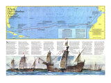
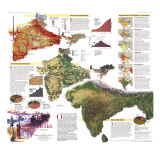
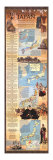
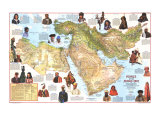
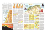
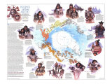
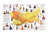
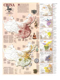
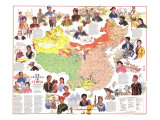
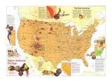
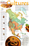
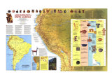
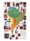
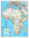
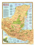
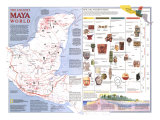
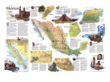
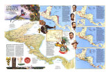
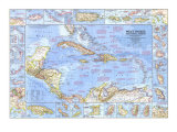
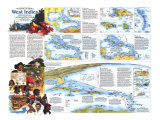
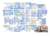
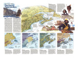
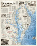
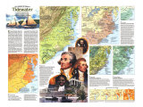
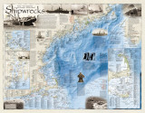
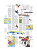
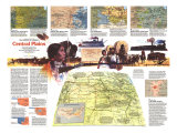
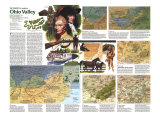
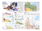
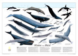
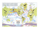
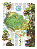
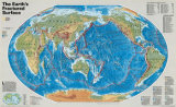
I have searched the web for visual, text, and manipulative curriculum support materials - teaching posters, art prints, maps, charts, calendars, books and educational toys featuring famous people, places and events - to help teachers optimize their valuable time and budget.

Browsing the subject areas at NetPosterWorks.com is a learning experience where educators can plan context rich environments while comparing prices, special discounts, framing options and shipping from educational resources.

Thank you for starting your search for inspirational, motivational, and educational posters and learning materials at NetPosterWorks.com. If you need help please contact us.


NPW home | Global PathMarker Collection | APWTW Blog | faqs-about | contact | search | privacy
links for learning & curriculum ideas | bookshelves | toybox | media | ecards | quotes

NetPosterWorks.com ©2007-2015 The Creative Process, LLC All Rights Reserved.

last updated 10/22/13

The Creative Process Educational Poster Directory at NetPosterWorks features visual instructional materials and resources, integrating content and design for learning across disciplines.