|
|
|
|
|
|
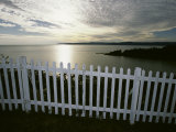
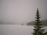
Newfoundland and Labrador consists of the island of Newfoundland in the Atlantic and Labrador on the mainland. St. Johns is the capital and largest city.
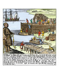
The earliest European contact was probably made over a thousand years ago by Leif Erikson; he called the place Vinland and the settlement is known as L'Anse aux Meadows.
Captain James Cook did the first mapping of Newfoundland.
|
|
|
|
New Brunswick, a maritime province, gets its name from the city of Brunswick (Braunschweig in German) in northern Germany, the ancestral home of the Hanoverian King George III of Great Britain.
New Brunswick is bounded by Gaspé Peninsula and Chaleur Bay of Quebec on the north, the Gulf of Saint Lawrence on the east, the Bay of Fundy on the south and the US state of Maine on the west.
Fredericton is the capital, and Saint John (not to be confused with St. Johns in Newfoundland Labrador) the largest city, in the province.
• Edward Mitchell Bannister, artist
• Walter Pidgeon, actor
• Donald Sutherland, actor
|
|
|
|
Nova Scotia, the second smallest Canadian province, is made up of the Nova Scotia Peninsula and several islands. Much of the current population are descendents of Loyalists who left the new United States the end of the American Revolutionary War.
Halifax is the largest city and capital of Nova Scotia.
• Abraham Pineo Gesner, geologist
• Ruby Keeler, actress
|
|
|
|
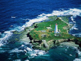
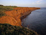
Prince Edward Island, the smallest Canadian province, is made up of an island of the same name and other islands in the Gulf of St. Lawrence. The island was named after Prince Edward, the father of Queen Victoria; Jacques Cartier claimed the island as a part of the French colony of Acadia.
Charlottetown is the capital and largest city.
• Lucy Maud Montgomery, author of Anne of Green Gables
|
|
|
|
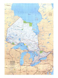
Quebec, Canada's largest province by area, is also the only province whose official language is French.
The French explorer Samuel de Champlain chose the name Québec, which was originally derived from an Algonquin word kébec meaning “where the river narrows”, as the name for the colonial administrative seat of New France.
FYI - in 2006, the Canadian House of Commons passed a symbolic motion recognizing the “Québécois as a nation within a united Canada.”
• Geneviève Bujold, actress
• Celine Dion, singer
• Glenn Ford, actor
• Mario Lemieux, hockey player
• Oscar Peterson, jazz pianist
• Mack Sennett, director
• Norma Shearer, actress
• William Shatner, actor
• Pierre Elliott Trudeau, politician
|
|
|
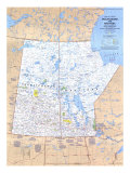
Ontario is the most populous province and second largest in total area in Canada. Ontario's Toronto is Canada's most populous city and Ottawa, the national capital of Canada, is in Ontario. Ontario shares Great Lake borders with the U.S. states of Michigan, New York (Niagara Falls), Ohio, and Pennsylvania, and a land border with Minnesota.
• Margaret Atwood, author
• Frederick Banting, physician
• Robertson Davies, author
• Marie Dressler, actress
• John Charles Fields, mathematician
• Frank Gehry, architect
• Glenn Gould, musician
• Graham Greene, actor
• Walter Huston, hockey player
• Farley McGill Mowat, conservationist & author
• Lester Pearson, statesman
• Mary Pickford, actress
• Barbara Ann Scott, figure skater
• Tecumseh, Shawnee Chief, voted 37th Greatest Canadian
• Jacob “Jack” Warner, film executive
|
|
|
|
Manitoba is the easternmost “prairie province”, the name means “strait of the spirit" or “lake of the prairies" and is thought to be from the Cree, Ojibwe or Assiniboine language.
Winnipeg is the capital and largest city of Manitoba.
The Red River of the North flows northward from the U.S. into Lake Winnipeg, which then drains into the Hudson Bay through the Nelson River.
• Adam Beach, actor
• Louis Riel, leader
|
|
|
|
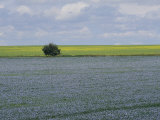
Saskatchewan is the middle prairie province, its name derives from the Cree word meaning “swift flowing river” for the Saskatchewan River.
Saskatchewan's largest city is Saskatoon, the provincial capital is Regina.
• more food posters
• Grey Owl
• Buffy Sainte-Marie
|
|
|
|
Alberta is the westernmost of the prairie provinces with the southwestern portion rising to the Rocky Mountains and the Continental Divide.
The capital of Alberta is Edmonton; Calgary is the site of the famous rodeo the Calgary Stampede.
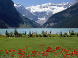
FYI - Alberta is named after Princess Louise Caroline Alberta, daughter of Queen Victoria and Prince Albert. Lake Louise is also named after the princess.
• more national parks posters
• Marshall McLuhan, author
• Joni Mitchell, musician
• Jamie Salé, figure skater
• Fay Wray, actress
|
|
|
|
British Columbia is the westernmost province. Victoria is the capital, Vancouver is the largest city and the 2010 host of the Winter Olympics.
• David Suzuki, ecologist
• Pamela Anderson, actress
• Michael Bublé, singer
• Raymond Burr, actor
• Kim Cattrall, actress
• Yvonne De Carlo, actress
• James Doohan, actor
• Chief Dan George, actor
• June Havoc, actress
• Sarah McLachlan, musician
• Joni Mitchell, musician
• Jamie Salé, figure skater
|
|
|
|
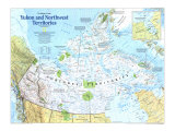
Yukon (founded 1898), North West Territories (1870) and Nunavut (1999) are territories with no inherent jurisdiction or powers. The territories consist of mainland Canada north of 60º latitude and west of Hudson Bay, including islands north of the Canadian mainland to the Artic. Whitehorse, Yellowknife and Iqaluit are the capitals and largest cities respectively.
|
|
|
previous page | top
Canada & Canadian Culture | PROVINCES
|
|
I have searched the web for visual, text, and manipulative curriculum support materials - teaching posters, art prints, maps, charts, calendars, books and educational toys featuring famous people, places and events - to help teachers optimize their valuable time and budget.
Browsing the subject areas at NetPosterWorks.com is a learning experience where educators can plan context rich environments while comparing prices, special discounts, framing options and shipping from educational resources.
Thank you for starting your search for inspirational, motivational, and educational posters and learning materials at NetPosterWorks.com. If you need help please contact us.
|
|
|