|
|
|
|
|
|
|
|
|
|
|
|
BOOKS ABOUT CITIES & URBAN PLANNING
|
|
|
|
|
|
|
|
|
|
|
|
|
|
|
|
|
|
|
|
|
|
|
|
|
 |
|
|
|
|
|
|
|
|
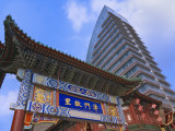
Tianjin, in northern China, is one of the five national central cities of the People's Republic of China (Beijing, Shanghai, Guangzhou, and Chongqing).
|
|
|
|
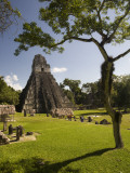
Tikal, in the tropical rainforests of present day northern Guatemala, was one of the major urban centers of the pre-Columbian Maya civilization.
Its monumental architecture dates back as far as the 4th century BC, and reached its highest achievement during the Classic Period, ca. 200 to 900 AD.
• Archeology of Middle America Poster Map
|
|
|
|
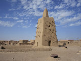
Timbuktu, in the West African nation of Mali, is situated on the southern edge of the Sahara Desert, just north of the Niger River.
Timbuktu began as a temporary settlement in the 12th century that became permanent with a shift in the trade route for salt, gold, ivory and slaves.
Today Timbuktu suffers the consequences of desertification though its name still evokes the aura of mystery that brings tourist dollars.
|
|
|
|
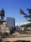
Tirana, capital and the largest city of Albania, is located about 20 miles inland to the east of the Adriatic Sea.
Tirana was founded as an Ottoman town in 1614, though the area has been continuously inhabited since antiquity.
|
|
|
|
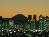
Tokyo, the capital of Japan and located on Honshu Island, is an alpha+ world city, part of the world's most populous metropolitan area, the world's largest metropolitan economy, and the world's most expensive city for expartriate employees.
Tokyo was originally a small fishing village named Edo. its name was changed in 1868 to Tokyo to reflect the East Asian tradition of including the word “capital” in the name of the capital city (also Beijing and Seoul).
Tokyo sits in the shadow of Mount Fuji, an active stratovolcano that last erupted in 1707–08; the last major earthquake was in 1923 with the loss of over 140,000 lives.
|
|
|
|
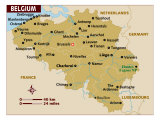
Tongeren is the oldest town in Belgium, founded in 15 BC, during Roman rule. Tongeren was destroyed by Louis XIV's army in 1677, from which it never regained its status.
Most Ancient European Towns Network: Argos, Beziers, Cadiz, Colchester, Cork, Evora, Maastricht, Roskilde, Tongeren, Worms.
|
|
|
|
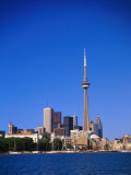
Toronto, the largest city in Canada and the provincial capital of Ontario, is located on the northwestern shore of Lake Ontario.
The name Toronto is likely derived from the Iroquois word tkaronto, meaning “place where trees stand in the water”, and referring to the Huron Indians planting tree saplings to corral fish.
Notable people associate with Toronto include John Charles Fields.
Toronto Calendars
|
|
|
|
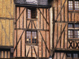
Since Gallic times, Turones, what is known today as the city of Tours, has been an important crossing point of the Loire River in France.
When the Romans conquered Gaul in the 1st century AD they called the place Civitas Turonum. Eventually five Roman roads met at Tours, connecting the Frankish north, Aquitaine and Spain.
As the center of the cult of Saint Martin, Tours was a pilgrimage site and political sanctuary with a hospital.
The Moors were stopped from advancing into Europe by Charles Martel and his infantry at the Battle of Tours (also known as Poitiers), Tours was a garrison town for the American Expeditionary Forces in WWI, commemorated by the Woodrow Wilson Bridge over the Loire; the city was also heavily damaged in WWII.
Notable people associated with Tours include Gregory of Tours, Alcuin, and Honoré de Balzac.
|
|
|
|
|
|
|
|
|
|
|
|
|
|
|
previous page | top | next
Cities of the World | a | b | c | d | e-f | g | h | i | j | k | l | m | n | o | p | q | r | s |
Ta-Tb | Te-Th | TI-TO | Tr-Ty | u | v | w | x-y-z
|
|
I have searched the web for visual, text, and manipulative curriculum support materials - teaching posters, art prints, maps, charts, calendars, books and educational toys featuring famous people, places and events - to help teachers optimize their valuable time and budget.
Browsing the subject areas at NetPosterWorks.com is a learning experience where educators can plan context rich environments while comparing prices, special discounts, framing options and shipping from educational resources.
Thank you for starting your search for inspirational, motivational, and educational posters and learning materials at NetPosterWorks.com. If you need help please contact us.
|
|
|