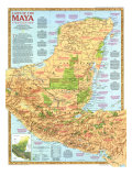
The 1994 Travelers Map of Mexico features:
• Introduction to Mexico's diverse landscape, sites of interest, and activities
• Inset maps of Baja California, Mexico City, the Yucatan Peninsula, and Copper Canyon
• Scenic routes from Mexico City
• A map and illustration of the ancient Mayan city of Chichen Itza
• Physical map of the Mexico
• Information on the folk art of the region
* Lesson plan idea - have your students update the information and latest statistics concerning Mexico; discuss the political, economic, and environmental situations that are current for the region. • maps
RICH AS THE HUES of a handwoven serape, Mexico is a land of many textures and traditions.
Machete-sharp mountain ridges flank fertile valleys. Lush tropical forests give way to unforgiving deserts (Chihuahuan, Sonoran). All are bound by more than 6,000 miles of varied coastline.
The contrasts of the land are mirrored in the people, who now number nearly 92 million (1994 data). While many share an ancestry that includes both indigenous groups and Spanish invaders, many distinct traditions have been passed on through the centuries and live in today's folk art, dances, and celebrations.
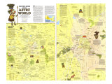
Before Europeans arrived, the Maya, Aztec, and others built enormous masonry structures, perfected complex systems of writing, and excelled in astronomy. The remains of their genius memorialize them from Teotihuacan to Chichen Itza, and the rhythms of their speech still echo in the languages of their descendants.
Spain invaded Mexico in 1519, destroying the Aztec Empire and subjugating native groups, and rulled until 1821, when revolution brought independence to Mexico. France gained a stronghold in 1864, establishing Maximilian, an Austrain archduke as emperor. Occupation ended in 1867, after opposition forced pressured France to withdraw. Within weeks President Benito Juarez, a Zapotec, court-martialed Maximilian, who was soon executed.
Mexico has since survived dictatorship and more revolts on its way to becoming a politically stable nation–yet a recent uprising of rebel groups in the southeastern state of Chiapas is a sign that old conflicts persist.
BAJA CALIFORNIA -
Torn from Mexico's mainland some five million years ago along the San Andreas Fault system, Baja California is hardscrabble country. Yet the nutrient-rich waters of the Gulf of California, also called the Sea of Cortes, attact abundant tuna, marlin, and other game fish, making ports on the southern tip of the peninsula a prime hemispheric center for sportfishing.
MEXICO CITY -
The megalopolis of Mexico City sprawls over 500 square miles. More than 30,000 factories and three million vehicles exhale 12,000 tons of pollutnts every day, creating a shroud of smog that hangs heavily over the highland basin most of the year. Yet, despite its environmental woes, Mexico City draws a million visitors annually.
The entire area is rich in history, with the heart of the city–built on the site of the Aztec capital of Tenochtitlan–comprising a wealth of archaeological sites, colonial buildings, and museums.
Thousand-acre Chapultepec Park is the public's estate. Pathways lead to the zoo, the Museum of Natural History and the National Museum of Anthropology, whose collection and architecture make it one of the premier museums of the world.
Near the main entrance to the park stands Chapultepec Castle, built in the 1780s by Bernardo e Balvez, a Spanish viceroy. In 1864 it became home to the ill-fated Emperor Maximilian and Empress Carlota. She is said to have prompted Maximilian to build the grand Paseo de la Reforma, modeled on Paris's Champ-Elysee, so that she could watch as he rode to the National Palace.
The Reforma leads to the Zocalo, a public square known for frequent political protests, Just to the northeast stand the ruins of the Templo Mayor, ceremonial center of Tenochtitlan and among the most important archaeological finds of this century. Workers digging a trench for an electric cable in 1978 unearthed a stone carving of Coyolxauhqui, Aztec goddess of the moon. This led to the discovery of some 6,000 artifacts now in the Templo Mayor museum next to the ruins.
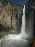
YUCATAN PENINSULA -
Rolling waves, jungle ruins, and wildlife reserves lure visitors to the Yucatan Peninsula. Flat terrain underlaid by limestone, it is bordered by more than 800 miles of coastline, marbled by lagoons, sandbars, and mangrove swamps. Coral reefs lie to the east.
From the high-rise resort of Cancun to the island of Cozumel, sunseekers flock to the Caribbean's warm, clear waters for wind surfing and snorkeling.
Perched on a cliff farther south are the well-preserved ruins of the walled Maya city of Tulum–a religious and trade center for seagoing merchants. Inland at Coba, the pyramid of Nohoch Mul rises 138 feet, one of the tallest Maya stuctures. To the west Uxmal contains what many consider the most beautiful examples of Maya architecture.
Some 25,000 Caribbean flamingos–one of the largest colonies in the world–set the northern coast ablaze in late May when they gather near Rio Lagartos.
Campeche retains seven fortresses and portions of a wall built to ward off 17th-century European pirates cruising the Gulf of Mexico.
CHICHEN ITZA -
Master builders, the lowland Maya flourished after A.D. 250 for at least a thousand years. Ruins of their cities dot the Yucatan Peninsula.
While Europe endured the Dark Ages, the Maya established scores of city-states. Governed by hereditary rulers, city-states often shared power as political allies. The Maya developed the most sophisticated system of writing in the Western Hemisphere, traced the path of the planet Venus with precision, and marked the passage of time with an elaborate calendar system.
Between A.D. 500 and 1200 the Maya built Chichen Itza. Encounters with other Mesomaerican cultures may have influenced the blend of architectural styles at this commercial and ceremonial center, where archaelogists have revealed steam baths, ball courts, temples, and what may be an observatory. The focal point of Chichen Itza is El Castillo, a 79-foot-high pyramid crowned by a temple.
El Castillo is thought by many to be the Maya calendar constructed in stone. Its four staircases have 91 steps each; include the top platform and the total is 365, the number of days in the solar year.
Inside the pyramid is yet another building of similar construction that houses a jade-inlaid throne in the image of a jaguar, a symbol of power. Nearby a sculptured human figure, a Chac Mool, may have served as an altar for religious offerings.
MEXICO'S LANDSCAPE MOSAIC -
Though most of Mexico consists of convoluted mountain ridges and highlands, the terrain of its 31 states shows marked differences.
The Yucatan Peninsula flattens as it trails from the forested heights in the south. The central highlands around Mexico City receive enough moisture–most between May and October–to grow beans, corn, and potatoes. Deserts dominate the northernmost reaches of the mainland and Baja California, where farmers rely on irrigation to produce wheat and cotton. Coastlines vary from craggy cliffs to wide beaches of white or black sand.
COPPER CANYON - (Chihauhua State - 28º48'51"N 106º26'22"W)
Scoured over time by torrential rivers, the Copper Canyon region reveals a spectacular wilderness deeper in places than Arizona's Grand Canyon. Trains ferry passengers 8,000 feet up from Los Mochis to Creel, where backpackers stop off to hike into the steep gorges.
The Tarahumara, indigeonous people famous as endurance runners, began to migrate here 400 years ago to escape enslavement in Spanish silver mines. Today some 70,000 Tarahumara raise corn and goats on the high plateaus, far from the reach of the modern world.
MEXICO'S FOLK ART -
Mexican folk art reflects artisans' cultural histories and views of the environment. Artists often use materials supplied by nature–gourds, clay, palm fronds, or wood–to create practical housewares, docorative objects, musical instruments, and religious icons.
Collectors wander the local markets, where they can find palm-fond figures crafted in Puebla, ceramic trees of life fired in Acatlan, rebozos, or shawls, woven in Tenanicingo, and dance masks carved in Iguala.
Passed from one generation ot then next, from mentor to student, skills are shared by entire families, who create pieces for each other and their neighbors that may fnd their way to museums and the galleries of private collectors. Yet economic need has caused many artists to produce their work in great quantity for export, removing their craft from the realm of traditional folk art. “What makes true folk art is how it is used,” says Marion Oettinger, Jr., curator of Latin American Art at the San Antonio Museum of Art in Texas. “It changes with the needs of the people. It dies every day and is born every day.”
SCENIC ROUTES FROM MEXICO CITY -
Strike out in any direction for side trips to the Gulf of Mexico, volcanoes, Pacific beaches, historical towns, and archaelogical ruins.
• Trail to the Gulf - At El Tajin the Pyramid of the Niches remains a masterpiece of pre-Columbian architecture. The coastal road leads to Veracruz, at one time the country's busiest seaport. Xalapa opens to views of Pico de Orizaba, Mexico's highest mountain. Return to Mexico City by way of Puebla, where Talavera tiles adorn the buildings.
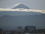
• Volcanoes - Popocatepetl and its sister volcano, Iztaccihuatl, rise into view on the way to Oaxaca, where Mixtec and Zapotec Indians sell crafts at market. Volcanoes can also be seen from Cuautla, famed for hot sulfur springs.
• Acapulco - The flower-draped city of Cuernavaca is the first stop on this route. Next comes Taxco's cobblestone streets, winding past countless siver shops. Farther on lie the resorts of Acapulco and Ixtapa.
• History - The colonial city of Queretaro was the center of rebellion against Spain. The cry of revolution rose from Dolores Hidalgo, where the armed struggle for independence began in earnest in 1819. Curving roads lead to the urban beauty of Guadalajara through Mexican towns famous for their handicrafts.
• Archaeology - The Pyramid of the Sun dominates the pre-Aztec city of Teotihuacan. Ruins at the Toltec capital of Tula center on several stone figures that supported the roof of a temple.