|
|
Mediterranean Sea Maps, Posters, Prints, Charts
for oceanography and marine geology science, environmental, ecology, and geography classrooms.
|
social studies > geography > landforms > oceans > MEDITERRANEAN < aquatic/marine < water < science
|
|
|
“Sea in the middle of the land,” as its Latin name aptly translates, the Mediterranean has been molded in a vise of colliding continents. Beneath its waters–an expanse some 3,700 kilometers (2,300 miles) long and 1,100 kilometers at its broadest–a chain of basins and striking features reveals the forces of plate tectonics.
Geologists believe that about 200 million years ago a single great landmass, riding on Earth's molten interior, began to split in to continental plates. Between the Eurasian and African plates lay a vast ancient sea called Tethys. Africa moved north; the plates closed like jaws, consuming Tethys. A remnant became the Black Sea, and an entirely new sea developed, which eventually became the Mediterranean.
The continental jaws tightened, and the African plate began diving beneath the Eurasian plate. The squeezing split off pieces of North Africa. A chunk that became Italy was driven into Europe, thrusting up the Alps. Corsica and Sardinia were stretched and pulled away from France and Spain as the plates continued to collide. Fed by lava from deep within the Earth, a cluster of volcanoes grew along the plate boundaries near Sicily, and the plates' jostling rocks Italy with earthquakes. The two continents are still colliding bead-on in the western Mediterranean.
This is not the case farther east, where Africa's unsettling dive continues, marked by the long sinuous scar of the Mediterranean Ridge. Above it sits the Aegean, a drowned extension of Asia Minor. Crete rises from the leading edge of the Aegean arc that reaches from western Greece toward Turkey. Burrowing beneath it, the African plate creates a pulling force on the Aegean seafloor. Thus Crete and Libya ride toward one another on a collision course, one day to raise mountains on the African coast.
Could the Mediterranean have shrunk into a virtual desert? Core samples from the seafloor have revealed salt deposits more than two kilometers thick–evidence of almost total evaporation–as well as the extinction of virtually all aquatic life about six million years ago. Geologists believe that long after a connection to the Indian Ocean was shut off, the Mediterranean's gate to the Atlantic was also dammed as Europe and Africa ground together at Gibraltar, reducing the sea within to scattered lakes. High above the dry basins, coastal rivers carved steep gorges as they plunged toward the bottom. Yet fossils show a return of marine creatures in only half a million years–a geologic eye blink. Perhaps an earthquake or the rising Atlantic breached the dam at Gibraltar, reflooding he Mediterranean in an awesome deluge lasting only a century.
|
|
|
|
PHOENICIAN - Even before 800 B.C. seaborne merchants from Tyre and Sidon plied the eastern Mediterranean, spreading the alphabet later adapted by Greece and passed to the Western world. Colonizing Carthage as early as 814 B.C., these traders expanded their markets across the western sea into the Atlantic, until Rome crushed their power in 146 B.C.
GREEK - In the eighth century B.C. Greeks colonized southern Italy and Sicily. Around 600 B.C. Greek sity-states began competing with the Phoenicians and later fended off Persian invaders from the east. Alexander the Great united the fractious cities; his empire eventually extended ot India. Rome swallowed Alexander's Hellenistic kingdoms in the second and first centuries B.C.
ROMAN - Beginning with the conquest of Italy in the third century B.C., Rome's military juggernaut defeated both Greeks and Carthaginians, while building an empire from Africa and Asia to distant outposts in Britain. Waves of Germanic invaders ended Rome's heyday in the fifth century A.D. and Mediterranean power shifted east to Byzantium.
BYZANTINE - Old Byzantium, the new Constantinople rose as a center of Christianity in A.D. 330. Strong Greek roots eventually supplanted Latin influences. Emperor Justinian spread Byzantine rule briefly to Spain and Africa before their conquest by Muslim powers. Crusaders, Byzantines, and Muslims collided in the Holy Land in the 11th century.
ISLAMIC - Whirlwind of faith after A.D. 622 blew the world of Muhammad across North Africa to Spain and into France. Innovations of Muslim craftsmen left their mark on European arts. In time Christians regained control in the west, while Seljuk Turks resisted waves of crusaders in Asia Minor and took Constantinople in 1452, toppling the Byzantine Empire.
Heart of an Expanding World -
“We ... live ... like ants or frogs about a pond ...” Thus the Greeks came to realize how their home sea dwarfed them, as they wrestled to define a “very large” Earth not with mythology, but with science. In Homer's time the notion of a flat disk prevailed. Thales of Miletus argued about 585 B.C. that the disk floated on water. Anaximander envisioned a cylinder crowned by a disk of inhabited land, while Anaximenes proposed a rectangle hovering on compressed air. Pythagoras decided on the sphere; Aristotle agreed, using hard evidence such as the curved shadow projected by the Earth on the moon during eclipse. Eratosthenes was first to calculate Earth's circumference but overestimated it by about 16 percent. His critic, Ptolemy, later undershot the mark by a fourth. “Heresy!” cried ecclesiastical scholars of the Middle Ages, because scientific advances did not jibe with their strict scriptural interpretations of the world. In place of learned debate, hearsay ran rampant with tales of monstrous horse-footed men and boiling rivers that colored maps for centuries. ...
The World of Homer, ca 700 B.C.
“The limits of the world ... Oceanus” girdled the lands of the Odyssey described by Homer, who may have lived in Chios or Smyrna during the eighth century B.C. Beyond Greece's familar isles the rest of the Mediterranean remained a vague outline.
The World of Herodotus, ca 465 B.C.
Earth expanded to three continents–Asia, Europe, and Africa (Libya)–based on the conclusions of the first great historian, born in Halicarnassus about 484 B.C. From Phoenician sailors' accounts, Herodotus declared that “Africa is washed on all sides by the sea, except where it is joined to Asia.”
The World of Strabo, ca 25 B.C.
Witness to the rise of the Roman Empire, Stabo was born about 63 B.C. at Amasia in Asia Minor. His Geography summed up the ancient world, defining boundaries and distances between cities. Criticizing earlier geographers who had split the Atlantic Ocean, he pronounced it “one confluent and continuous sea.”
Ptolemy's World, ca A.D. 140
Concepts of latitude and longitude were employed by Claudius Ptolemaeus at Alexandria about A.D. 140. Yet his errors–an earth-centered universe and an exaggerated Eurasia–long outlived him, as shown by a 1490 map based on his work.
The Hereford Map, ca A.D. 1290
In medieval works known as “T-O” maps the encircling ocean forms the O. With east at the top, the Mediterranean is the T's upright leg. Crossing it are the Nile and Don Rivers, as the Asian boundary. Jerusalem thus dominates the center. The Hereford Map is preserved in England's Hereford Cathedral.
|
|
|
|
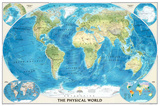
World Physical Map of the Ocean Floor
|
|
|
|
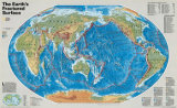
The Earth's Fractured Surface Map
National Geographic map shows the tectonic plates in their current configuration, and describes how landforms are reshaped over millions of years. Scale of 1 inch to every 757 miles. - more text
• geology posters
|
|
|
|
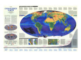
Endangered Earth Map
National Geographic map pinpoints the growing threats to the delicate balance between development and natural regeneration of the planet.
• ecology/environoment posters
|
|
|
|
|
previous page | top
|
|
I have searched the web for visual, text, and manipulative curriculum support materials - teaching posters, art prints, maps, charts, calendars, books and educational toys featuring famous people, places and events - to help teachers optimize their valuable time and budget.
Browsing the subject areas at NetPosterWorks.com is a learning experience where educators can plan context rich environments while comparing prices, special discounts, framing options and shipping from educational resources.
Thank you for starting your search for inspirational, motivational, and educational posters and learning materials at NetPosterWorks.com. If you need help please contact us.
|
|
|