|
|
|
|
|
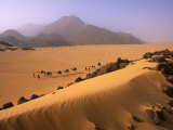
The Sahara, the largest desert in the world, covers much of northern Africa. On the west of the Sahara is the Atlantic Ocean and the Atlas Mountains, the Mediterranean Sea are to the north, the Red Sea and Egypt are on the east and the Niger River is to the south.
The Sahara is so large that regions are further identified: the Nubian Desert of Sudan, is in the eastern region between the Nile and Red Sea; the Libyan Desert is in southwestern Egypt, eastern Libya and western Sudan; the Tenere Desert is in the south central area.
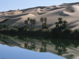
Dunes, bodies of sand shaped by wind, are iconic of the Sahara and are called “erg”, stone plateaus / “hammada”, gravel plains / “reg”, dry valley / “wadi”, and salt flats / “shatt”; an oasis occurs where underground water, an aquifer, is close to the surface. Along parts of the northern edge is a narrow Mediterranean climate; the southern transition area of the Sahara is called the Sahel.
• “The gap between the committed and the indifferent is a Sahara whose faint trails, followed by the mind's eye only, fade out in sand.” ~ Nadine Gordimer
|
|
|
|
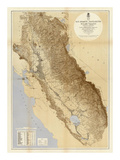
San Joaquin Valley, the southern area of the Central Valley of California, is semi-arid from the rainshadow effect of the coastal ranges.
Despite climatically being a desert, irrigation of the land has made the United States depend on the San Joaquin Valley for nearly 13% of the national agricultural production. In the 1970s there were numerous strikes and boycotts of table grapes, called for by the United Farm Workers lead by Cesar Chavez and Dolores Huerta due to the strong arm tactics of the white farmers against the workers.
FYI ~ Ironically the San Joaquin Valley is considered a food desert when it comes to the availability of food to the people who live there.
|
|
|
|
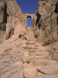
Sinai Peninsula is primarily desert with a variety of landforms from mountainous to sandy, forming a natural buffer zone between Africa and Asia.
The peninsula is extemely arid, though the wadis, or ancient dry river beds, are evidence of a time when there was more precipitation that would cause water erosion.
The name Sinai is from Mount Sinai, the place where the Ten Commandments were handed down to Moses.
|
|
|
|
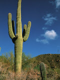
Sonoran Desert straddles part of the United States-Mexico border, covering large parts of the U.S. states of Arizona and California and the northwest Mexican states of Sonora, Baja California, and Baja California Sur. The Mojave Desert is to the northwest of the Sonoran Desert.
The Saguaro National Park, in the Sonoran Desert, protects some of the most impressive forests of these sub-tropical cacti giants. The cities of Phoenix and Tucson, Arizona, and Palm Springs and Palm Desert, California are in the Sonoran Desert.
FYI ~ Sonora is a Spanish word which means loud, clear, sonorous, harmonious and audible. It also a species of ground snakes.
According to 1990 census, Sonora is a very rare first name of females as well as last name in the United States of America. In addition to being a name of a desert Sonora is also the name of an island, a peak, a river, a city in the states of Ohio, California, Kentucky and Texas USA. It is also a state in northwestern Mexico and its capital is Hermosillo.
Meteorologically, Sonora is also the name of a thunderstorm which occurs in the mountains and deserts of Southern California and Baja California during the summer season. Sonora is also the name of a 1969 Western movie.
|
|
|
|
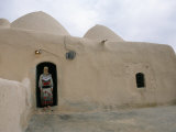
The Syrian Desert, the 9th largest desert on Earth, is a combination of steppe and true desert that is located in the northern Arabian Peninsula covering parts of Syria, Iraq, Jordan, and Saudi Arabia.
Among the oases of the Syrian Desert are Damascus and the archeological ruin of Palmyra.
Lady Hester Stanhope was a socialite who traveled in the Syrian Desert by caravan, dressed as a Bedouin.
|
|
|
|
previous page | top | next
landforms > deserts > a | b-f | g-j | k-l | m-n | o-r | S | t-z
|
|
I have searched the web for visual, text, and manipulative curriculum support materials - teaching posters, art prints, maps, charts, calendars, books and educational toys featuring famous people, places and events - to help teachers optimize their valuable time and budget.
Browsing the subject areas at NetPosterWorks.com is a learning experience where educators can plan context rich environments while comparing prices, special discounts, framing options and shipping from educational resources.
Thank you for starting your search for inspirational, motivational, and educational posters and learning materials at NetPosterWorks.com. If you need help please contact us.
|
|
|