* Lesson plan idea - illustrate tectonics; set up gallery of Himalaya views; • maps
THE MIGHTY HIMALAYA. The highest mountains on Earth hold different meanings for different people. To the Nepalese the mountains are a home, an obstacle, and a sacred presence. To climbers Himalayan summits present ultimate challenges. Travelers find inspiration and renewal among the soaring peaks an plunging valleys; every year thousands of trekkers hike in the vicinity of Mount Everest, a newly resurveyed region rendered in precise detail.* To geologists the range, which is still rising, epitomizes the crushing and folding of Earth's crust when two continental plates collide. To conservationists the mountains contain a rich but imminently threatened concentrated of biological habits.
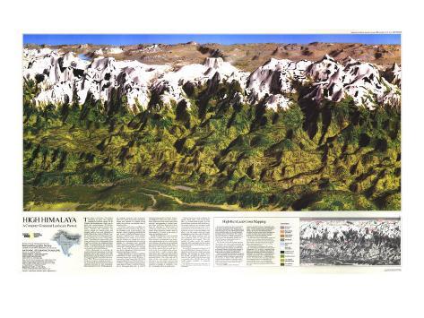
Neither photograph nor painting, the computer-generated panorama of the high Himalaya shown here extends from near Kathmandu in central Nepal to just east of Everest and includes the southernmost portion of Tibet. The scene demonstrates an exciting new computer-mapping technique – the combining of information about natural vegetation and land use with topographic data in a perspective view. With sophisticated computer programs and equipment, land-cover classes interpreted from satellite images were married to a digital terrain model derived from conventional maps of the land surface.
For all their visual drama, such high-tech portraits only hint at nature's rich fabric in the Himalaya – and at the problems that threaten. Nepal's population doubled in the past 30 years. A third of all Nepalese live on the plain, called the Terai, whose northern edge appears on the image. At an accelerating rate, Nepalese are cutting down mountain forests for fuel and fodder and terracing hillsides for subsistence plots. Denuded slopes absorb less rainfall, contributing to catastrophic flooding during the monsoon season. In mid-1988 flood waters engulfed two-thirds of Bangladesh, killing thousnds and leaving millions homeless.
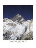
Against a backdrop of poverty and fierce competition for land, conservationists are moving to protect the central Himalaya. A proposal to enlarge Sagarmatha (the Nepali name for Mount Everest) National Park – a UNESCO World Heritage site and one of five major parks in Nepal – would more than triple it 480-square-mile area. A preserve adjoining Sagarmatha in China's Autonomous Region of Tibet is also under consideration. Approval of both would create a huge sanctuary encompassing a hundred summits above 20,000 feet. Everest juts above them all, although its official height of 19,028 freet (8,848 meters) has been challenged. More important, though, than the sheer grandeur of Everest is the variety of plants and animals around it.
Wildlife in the Himalaya varies accordingto altitude, sunlight, rain, snow, and soil. These elements work together in an apparently infinite number of ways, so that within short distances life zone can be identified that represent habitats around the globe. A Himalayan valley spanning 3,000 to 27,000 feet contains species that one could find at sea level only by traveling from the subtropics to the Arctic. A valley's sinuous alignment means that while one slope receives long hours of intense sunlight, another lies in perpetual shadow. One valley soaks up 200 inches of raina a year; another, only tens of miles away in a rain shadow, gets less than ten inches. And in any valley, changes in soil contribute to changes in vegetation. Conifers, for example, thrive in sandy areas.
Not far from Everest to the southeast, the pristine Barun Valley – and several others like it – is a small world in itself. At 3,000 feet wild boars rootle in a thick bed of decaying organic material, and macaques swing in an orchid-decked monsoon forest. Chestnuts and trees of the tea family give way to temperate forests of oaks and maples, and above 7,000 feet alpine meadows open up along ridgetops, home of musk deer and the endangered snow leopard. The cold, rarified air above 16,000 feet sustains marmots, tahrs, and plants, such as lichens and hardy grasses, found otherwise only in tundra settings.
In considering expansion of preserves in the central Himalaya, Nepal and China recognize the need to protect fragile mountain habitats. The proposals are timely, and if they include controlled development programs for the benefit of hard-pressed rural communities, they will offer the rest of the world notable examples of pragmatic conservation.
High-Tech Land-Cover Mapping
To create this perspective view, a team of computer experts combined satellite pictures iwth conventional topographic maps. Using elevations from these maps, they took otherwise flat pictures and create the illusion of a three-dimentsional landscape. Most of the technical work – state of the art for this kind of mapping – was done by Dynamic Graphics, Inc., the Jet Propulsion Laboratory (JPL) and KRS Remote Sensing. The Society's Computer Mapping Laboratory coordinated the production effort.
The first step in marrying the maps and stellite pictures ws to make a mathematical grid of cells. Contour lines and elevation points from the topographic maps were digitized, or translated in to the language of computers, and technicians at Dynamic Graphics directed their computer to position them on the grid. The digitized leevations served as the skeleton for the terrain.
Patterns of vegetation and land use recorded by satellite added flesh. Orbiting Earth 438 miles up, the Landsat 5 satellite imaged four scenes of the Everest region in 1985 and 1986. Different types of land cover have different reflectance values and the satellite's scanner sensed light reflected from Earth's surface in both visible and near-infrared wavelengths.
Scientists at KRS analyzed the data by compuer, identified 25 types of vegetation with similar reflectance signatures, and mosaicked the images. A series of field checks, or ground-truth surveys, ensured that the vegetation classes matched the actual ground cover at selected sites in Tibet and Nepal. Even so, land-use experts estimate less than perfect accuracy, because steep slopes can skew spectral values.
To meet the Society's needs, KRS simplified the 25 classes to ten and gave each a natural color. The land cover and elevation grid were merged, cell by cell, and sent to the Jet Propulsion Laboratory to be made into an oblique image of the the high Himalaya.
As if composing a photograph, JPL's technicians instructed the computer to view the scene in a certain way. The “eye point,” equivalent to the position of a camera's viewfinder, lies about 100 miles south-southwest of Everest at a height of 60,000 feet. The “look point,” or direction of view, is slightly east of north. The 35-degree field of view corresponds to that of a 70-millimeter camera lens. To accentuate the mountains, elevations were exaggerated four and a half times. The computer added realism to the landscape by shining the light of an imaginary midmorning sun on the image and painting in shadows behind the peaks.
• perspective posters
• Rockies map