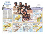
* Lesson plan idea - have your students update the information and latest statistics concerning the Northeast region of the United States; discuss, contrast and compare the political, economic (employment), and environmental (climate change) situations of the Northeast area. • maps
It was, the visitor noted, “a very pleasant place situated amongst certain little steep hills, ” where “...there ran down into the sea a great stream of water.” Today the world's longest suspension bridge – 4,260 feet – leaps that “great stream” and bears the name of New York's first European visitor: Giovanni da Verranzano, an Italian sent exploring by the French in 1524.
In 1609 the English navigator Henry Hudson – backed by Dutchmen whose countrymen would soon settle New Amsterdam – explored the river that now wears his name. Two visitors, but they represented four nations – and from their day to ours, the lands that fan out to the north, south, and west of this “very pleasant place” have welcomed not a single race of nationality but an endless mix of humankind.
In time the land became England's. The Crown gave the new colonies old names: York and Jersey, William Penn asked the king not to honor his father, a naval hero, but his colony's woodlands too; hence Penn-sylvania. Other nationalities kept flooding in, and names on the land honor them too: Pulaski and Rotteram in New York, Sligo and Karthaus in Pannsylvania, Cardiff and Bayonne in New Jersey. And names such as Oneida and Susquehanna remind the descendants of immigrants that here the Indian greeted the incoming tide that would all but wash him away.
NEW YORK - Many first-time visitors heading toward New York State smugly assume they know exatly what's there: New York City and, up the road a piece, Niagara Falls.
What surprises await them – and any other visitor who has never waded an Adirondack trout stream, toured a Finger Lakes winery, sunned on a Long Island seashore, rattled across an upstate covered bridge, or hiked the slopes and lakeshores of the Catskills with the grizzled shade of Rip Van Winkle. Along the 400 road miles between New York City and Niagara, along the Adirondack Northway arrowing toward Montreal, along landscaped turnpikes and city streets and shady byways, New York arrays enough variety of scenery and activities to surprise even some who say they've seen it all.
New York State wears not one face but three. There is the serene, unhurried face of farms and wilderness and long, open beaches, or lakes and ski trails and islands and waterfalls. There is a face with sweat on its brow and money in its pocket; it is the look of cities across the state's midsection where factories hum and goods pour out for the markets of the world. And there is the face that everyone knows, yet no one knows completely: the “Big Apple,” host and banker and tastemaker to much of the Western world. New York City.
As New Yorkers themselves will tell you, you have to be a little crazy to live in their city – or even to visit there. Crazy about the taste of Hungarian palacsinta, Italian cannoli, kosher corned beef on a slab of crusty rye. Crazy about cool blue jazz, the din of cheering thousands in a cavernous stadium, the clip-clop of horses as top-hatted drivers whisk riders through Central Park in a hansom. Crazy about the scent of chestnuts roasting on a pushcart, zeppoles bobbing in the caldron of oil, parfums beckoning from a swank Fifth Avenue counter. And crazy about superb zoos, museums, stores, galleries, music, theater, nightlife. The visitor who is crazy about anything will almost surely find heart's content in one of the most popular cities to visit in all the world.
See the Big Apple from atop the stupendous World Trade Center or the venerable Empire State Building. Watch its bar-graph skyline change as you circle it in a tour boat. Gaze into its heady canyons from a sight-seeing helicopter. Let distance shrink it to a child's stack of blocks as you view it from the Statue of Liberty or decks of the Staten Island Ferry – whose round trip takes about an hour and costs a pedestrian only a quarter*.
Then see the city afoot. Stroll its neighborhoods – each almost a town unto itself – and watch them shade from Irish to Chinese to Latin to Slavic to black. Feel the pulse of commerce in nidtown skyscrapers and the halls of fortune along Wall Street. Visit the United Nations, where – as in its neighborhoods – New York holds the world in the hollow of its hand.
From the car windows the countryside slowly rolls past – valley country, charming, often pastoral, generally flat. Like strings of beads, solid old citadels of industry of the New York Thruway: Utica, Syracuse, Rochester, Buffalo, the economic pillars of the state's northern fringe. Their smaller sisters, Binghamton, Elmira, Corning, thread Route 17 along the southern tier. Each of these “other” New York cities can tempt you to tarry – Corning with its famed glassworks and superb museum, Rochester with opera under the stars and the museum and tours of Eastman Kodak, Elmira with sailplane rides and the National Soaring Museum.
Only a few miles off the highways smiles a face of New York that often goes unseen. Look for this unspoiled face along the clean beaches of Long Island. See it in the glass-clear waters of Lake George or the fish-filled deeps of the glacier-cut Finger Lakes. Find it in the wine region around Hammondsport or the tradition-rich bastion of West Point. Or atop the forested peaks of the Adirondacks, once grand as the Rockies, now deeply eroded but still boasting the highest skiing peak in the East – 3,780-foot Whiteface Mountain. Wander among the spectacular Thousand Islands, all 1,870 of them – and side-trip to the St. Lawrence Seaway to drive your car under a ship! New York is a feast of such surprises.
ALBANY: Capitol, Emprie State Plaze towers include offices. BAINBRIDGE: Canoe regatta. CATSKILL MTS.: Forest preserve; year-round resorts. COOPERSTOWN: Baseball Hall of Fame. HAMMONDSPORT: Winery tours. HUNTER: German Alps Festival. LAKE PLACID: 1980 Olympics. NEW YORK: everything. NIAGARA FALLS: natural wonder. PALMYRA: Joseph Smith Home. PENN YAN: Finger Lakes. RHINEBECK: Old plane museum ROME: reconstructed Fort Stanwyx; restored section of Erie Canal. SARANAC LAKE: Winter Carnival. SARATOGA: Thoroughbred racing. UTICA: Brewery. WATKINS GLEN: Scenic Gorge; Formula 1 Grand Prix. WEST POINT: Military Academy.
NEW JERSEY - “Take a walk on the Boardwalk.” reads a card from a stack labeled “Chance.” The name of the game is Monopoly – but the names of its strees are New Jersey's. In Atlantic City the game board comes alive as you stroll Ventnor Avenue, St. James Place, and the fabled Boardwalk, named not for its lumber but for its creator, a New Jerseyite named Boardman. And in the city's future there is chance aplenty: State law promises the long-lived seaside resort a new life as the Las Vegas of the East.
Over the generations, Atlantic City has transformed its stretch of sand into a glittering bauble. Resorts, convention sites, saltwater-taffy stands, amusement pavilions, and night spots crowd the Boardwalk, where grown-ups still ride in motorized wicker rolling chairs while city swains flex biceps for awed girl friends. Other beach resorts, from Cape May to Asbury Park, have similarly adorned their bits of Jersey shore to entice vacationists from new York and Philadelphia and anywhere else.
Across their front stoops, and for mile upon lonely mile between, stretches of New Jersey's reigning tourist lure: 130 miles of ocean beach, skirted with islands, dimpled with bays, underlined by the Intracoastal Waterway. Fishing boats chug in and out, bound for sport or livelihood. Bird-watchers eye the sky, beachcombers scan the sand, artists sketch the occasional lighthouse or skeletal skiff moldering on a dune that may hide the hoard of Cap'n Kidd. it's a shore for all seasons, all tastes.
Seen in outline, this fifth smallest state is a bent old codger in a pillbox hat, turning his weary back on a sea that denies him a deepwater port in all that span of sand. The big ships dock at such ports as Elizabeth at the nape of his neck and Camden at the knot of his tie – one in the shadow of the great port of New York, the other across the Delaware River from the busy docks of Philadelphia. Like lightning zapping from nimbus to nimbus, rails and highways skitter up and down the old man's collar, linking the urban hubs and completing the circuit of the East's vast megalpolis. Yet New Jersey adds to the circuit no city quite so great as these – hence its image as a corridor state and its schizophrenic lean toward New York in the north, Philadelphia in the south.
Passing vacationists who simply cut across the old man's throat are, in a sense, cutting their own as well. They miss the boggy beauty of the Pine Barrens of south Jersey, nature's haven from the state's industrial midriff. Dotted with cranberry bogs and ringed by orchards and truck farms that give the “Garden State” its nickname, more than a million acres of sandy soil and scrub trees cradle one of the Northeast's richest museums of plant life. Here and there a ghost town or abandoned farmstead laments the death of dreams in soil unsuited to the plow. Here, too, buzzes the unjustly maligned Jersey mosquito, endowed in folklore with pterodactyl size and dragon disposition.
Just passing through? Turn off the main roads for awhile. Roll through stylish commuter towns such as Short Hills and Summit, where morning trains harvest executives for the paper-shuffling mills of New York City. Seek out colonial-flavored gems such as Mendham, a manicured memorial to 17th century Yankee founders, or Batsto village, whose mills and shops echo munitions-making days of the Revolutionary War. Stroll into the Great Swamp, an incongruous pocket of wilderness so close to New York that it nearly got paved for a jetport. Discover rank upon rank of steep little mountains with lakes in the pockets; return in winter for skating, iceboating, and skiing.
A hundred battles were fought on New Jersey soil in the Revolution, and the history buff finds sites galore – among them Washington's headquarters at Morristown and the scene of his famed crossing of the Delaware near Trenton. Washington was only passing through on his way to forging a nation. You can be revolutionary. Tarry awhile.
ASBURY PARK; ATLANTIC CITY: Miss America Pageant. CAPE MAY: McAFEE: MORRISTOWN; NEW BRUNSWICK: OCEAN CITY:
PENNSYLVANIA - There are 44,700 miles of state-administered paved roads in Pennsylvania – more than in New Jersey and all of New England combined. Yet along those miles a driver might encounter such things as a horse and buggy reined by a bearded farmer or his bonneted wife. Or around the next curve one of the state's 300 covered bridges. Or an old fieldstone barn bright with hex signs. Or a battleground of the Civil War, the Revolution, the French and Indian War. Past and present are close neighbors in Pennsylvania, the “Keystone State” of the original 13.
One stretch of that highway network, Interstate 279, bores through a tunnel at Pittsburgh. Newcomers brace for belching steel mills smudging the sky, dreary slums scarring the cityscape, pollution slicking the Allegheny and Monogahela Rivers as they fuse into the Ohio. A quarter century ago they'd have found just that; past and present don't always make good neighbors.
Suddenly the tunnel ends. And so do the nightmares as Pittsburgh pillars a clean blue sky on gleaming skyscrapers and points that way downriver with a green park at the tip of her “Golden Triangle.” Thanks to an urban renewal that still draws gasps, Pittsburgh now draws tourists to hear it symphony, cheer its champions, sample its French and Greek and Italian restaurants, and enjoy its summer art and folk fests.
At the other end of the state, Philadelphia –spurred by the nation's Bicentennial – has also spruced up. Where the residue of commercialism once crowded stately Independence Hall, a green swath of parkland now sets off this historic jewel in fitting fashion. In narrow, cobbled Elfreth's Alley the stroller half expects to bump into an inky Ben Franklin or a Thomas Jefferson weighing words for a declaration of independence. And at Penn's Landing, where William Penn's Quaers left ship to launch their “Holy Experiment,” a waterside promenade leads by a striking museum building to ships of yesteryear: President Truman's yacht, Admiral Dewey's flagship Olympia, even a windjammer that's a floating restauran. Like Pennyslvania's other big city, Philadelphia is at peace with its past, a fitting reliquary for the Liberty Bell, the Betsy Ross House, and the birthplaces of a nation.
Between the two pivotal cities, Pennsylvania strews a wrinkled rectangle some 300 miles long and 170 wide. Fingers of the Appalachians curl across most of the state – and through them punches the Pennsylvania Turnpike, one of the nation's first super-roads. Startled travelers may leave blue sky at one end of the tunnel and emerge into a cloudburst at the other.
Grazing past New Jersey's beetling brow, the ridges fold into the Pocono Mountains, mecca for droves of newlyweds seeking cool days, quiet trails, whispering woods – and perhaps the heart-shaped beds and bathtubs at a sprinkling of honeymoon havens.
To the west the ridges level out. There in the north corner the Allegheny National Forest welcomes boater, hiker, and fisherman. The south corner holds the Laurel Highlands, hilly and wooded, where the Olympic white-water team trains on a river whose name is an even greater challenge: Youghiogheny. Neophytes, too, can brave the river, bobbing downstream in fat rubber rafts with outfitters at the paddles. State parks dot the area, and indeed the whole state, fulfilling an official vow to put a park within 25 miles of every resident.
In the 1700s there was little but land to lure the immigrants who stepped ashore at Philadelphia and introduced themselves as Deutsch – German. But the “Pennsylvaia Dutch” headed west to carve out farms and towns from a state that is still half in woodland. Today, though many live and farm by simple means, their yields evoke envy among their mechanized neighbors. And the aura of quiet, God-fearing lives, unhurried days, and picture-perfect farms makes the Pennsylvania Dutch country – roughly a hundred-mile sweep west from Philadelphia – the state's most visited vacationland.
AMBRIDGE: Snow Shovel Riding Contest. FORT NECESSITY: Relic of French and Indian War, scene of Washington's only surrender. GALETON: Woodsmen's Carnival. GETTYSBURG: Civil War Battlefield. HERSHEY: Chocolate. KUTZTOWN: Folk Festival. McCLURE: Bean Soup Festival. MEYERSDALE: Maple Festival. PHILABELPHIA: History. WASHINGTON: Covered Bridge Festival.