* Lesson plan idea - have your students update the information and latest statistics concerning the New England region of the United States; discuss, contrast and compare the political, economic (employment), and environmental (climate change) situations of New England and the Northeast area. • maps
It's said that no American ever comes to New England for the first time. That's because you've seen its face on a hundred calendars, a thousand Christmas cards. You've met its heroes – Paul Revere, Daniel Webster, Myles Standish – in every history book. Your “colonial” house and steepled church hark back to originals on vilalge greens throughout this five-state half of New England (Maine, included with Canada's Maritime Provinces map).
Yet New England will surprise you. Few regions its size can match its variety of seashore and mountain, city an forest, colonial heritage and right-now dynamism. You can drive through it in a day – but don't; shunpiking will lead you past farms and forest to picture-post-card towns whose bounteous church suppers will make you say “Amen!”
The weather may surprise you too. Sweeping across the land, it makes its last stop in New England; sea and mountains help make the leftovers unpredictable. Spring is rainy, but even in summer a two-week tour without at least a sprinkle is a stroke of luck. Yankee autumns vary like vintages; a wet summer ending in a hard frost sets trees aflame with color and crowds roads and inns with exultant foliage-watchers. Most winters bring good skiing – when big storms muffle the slopes in powder, staid old villages bulge with strangers in paradise..
Even Yankee lingo holds surprises. A submarine or hero sandwich is a “grinder” – and two hands full of good eating. Soda pop is “tonic” around Boston, recalling cure-alls of the 1800s that later became soft drinks. Boston's “frappe” is Providence's “cabinet”; both are milkshakes. R's dessolve on Yankee toungues; New Englanders will as you “whayah yuh pahked yuh cah.”
Come equipped for fun. You's find it no matter whyuh yuh pahk.
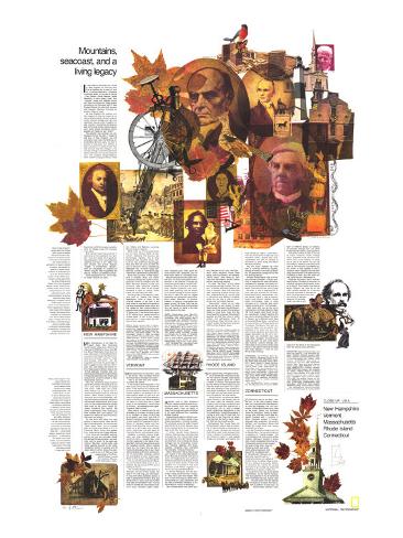
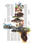
Faces of New England's heroes reflect the Yankee ideal–sturdy as maples that paint the hills in fall, supple as oval-leaved poplars or the lobe-leaved sassafras that made medicine for generations of people, resolute as cannon that boomed for freedom on village greens, stubborn as Bostonians who fell in the famed massacre limned in a Paul Revere print. Through a storied past march four-time Pulitzer winner Robert Frost; John Greenleaf Whittier, whose “Snow-Bound” indelibly evokes harsh winters; Emily Dickinson who wrote a thousand poems, a few published against her wishes before she died; Henry Wadsworth Longfellow whose village smithy can still be found in rural Yankee towns. Fierce-visaged Daniel Webster, white-maned Oliver Wendell Holmes, tight-lipped Calvin Coolidge, and aristocratic John Quincy Adams helped shape a heritage that echoes from Boston's Old State House, aerie for a gilded eagle, to Hartford's striking cluster of skyscrapers–looming from landscaped grounds that replaced a downtown slum.
Shie as New England snow, lofty as yankee faith, a Litchfield, Connecticut, church steeple clocks the chours as it invites congregationalistsº and camera buffs– to tarry. At Salem, Massachusetts, visitors feel the spell of witchcraft in the House of the Seven Gables, immortalized by Nathaniel Hawthorne. In Newport, Rhode Island, the gape at pillared Marble House and other mansions bult with forunes of the late 1800s. By may a roadside, today's travelers can see living museums: a tiny, shuttered Cape Cod half-house, to which later generatons might add the other half ... a long-roofed saltbox, evolved from house and lean-to ... a 19th-centruy sea captain's hip-roofed symbol of proud prospertiy, topped by a widow's walk where perils of his trade could leave his wife to keep vigil in vain.
NEW HAMPSHIRE -
Most mountainous of the New England states, New Hampshire counts hardly a level acre. Much of its area rises to 2,000 feet or more; its 6,288-foot Mount Washington looks down on every other peak in the Northeast. Such mountains have shaped the New Hampshireman's character – taciturn, frugal, hard-working, self-reliant, and yet hospitable and fond of a good laugh as folk in rugged country often are. Mountains also have shaped the state's history, keeping early settlers close the 18-mile seacoast, funneling later pioneers along valleys and through notches in the great granite barriers, feeding the streams that turned the wheels of their descendants' factories.
Now the mountains shape vacation plans of hundreds of thousands of visitors a year. Bowls between the peaks hold some 1,300 lakes and ponds, where boaters put in canoes and outbords while anglers pull out trout and salmon. Water carves wonders in ravines that vein the mountainsides, calling camera buffs and scenery seekers to innumerable waterfalls and rock formtions. On the forested flanks the camper finds sites by the score; higher up, toward timberline and beyond, the hardy outdoorsman finds challenging trails studded with rustic shelters, and jagged rock walls that dare him to break out ropes and wedges.
On one such wall hangs the state symbol, a natural profile called the Old Man of the Mountains. You can view the “Great Stone Face” from a vantage point at Profile Lake beside U.S. 3 in Franconia Notch. Bring field glasses for a close look at the craggy features.
From there the mountains towering around you give you the same choice they allowed the early traveler: you must drive north or south. To the north juts Cannon Mountain, whose cable cars whisk gasping tourists to the chllly, windblown summit in summer and lift eager skiers in winter. As you loop earward to join U.S. 302 you'll see rugged peaks of the Presidential Range–among them Jackson, Monroe, lordly Washington, Jefferson, Adams, and Madison–marching along in solemn cadence,
Head south out of Franconia Notch and you soon intersect State 112 near Lincoln. Eastward, 112 becomes the Kancamagus Highway, one of New England's most beautiful drives. Plan to picnic near 2, 855-foor Kancamagus Pass, then walk off lunch and feed the soul on the short trail to breathtaking Sabbaday Falls. Its name recalls sabbath-day outings of horse-and-buggy visitors who came here long before you.
More than four-fifths of New Hampshire is forested. Paper and lumber companies manage thousands of acres, especially in the far northern neck; the White Mountain National forest and numerous state preserves embrace thousands more. Most of the private woodland is open to visitors; check locally for road maps and rules.
No tree grows on the gale-torn, baldrock pate of “Misery Hill”– Mount Washington, home of some of the orneriest weather in the East. A toll road, a web of trails rated from gentle to just about impossible, and a quaint old cog railway all lead visitors toward a summit where tempertures have slid to 47º below zero F. and winds have roared at 231 miles an hour, a world record for surface gales. A visit to this rugged eyrie can be, in many ways, the high point of your vacation.
VERMONT -
“Pretty small farm you have here,” said the tourist. “Why, out West I drive all morning to the edge of my ranch.”
“Had a car like that once myself,” countered the Yankee.
If the incident never happened, it's at least a gem of wry-and-dry Yankee wit. And if it did, Vermont is a likely locale. Far from the glow of Boston and the industrial bustle of the southern tier of New England states, far also from the tides of immigrants that gave seaboard towns a rich ethnic mix, Vermont retains the flavor of times long lost in areas closer to the mainstream. “Come home to Vermont,” ad campaigns have urged; thousands heed the call.
Many secure a toehold with an old farmstead or a modern A-frame to trek to on holidays – so many, in fact, that out-of-staters own more than half of Vermont's vacation homes. Others come to stay, hoping for happiness in the alchemy of kerosene lamps and iron stoves, herbs blooming by an old farmhouse at a dirt road's end, wooden looms, clay bowls, and well water to rinse wild berries and callused hands.
Bargains in produce, pottery, woodware, and other craftwork await the tourist at many a roadside sign. Look for them especially in the region of isolated dairy farms and deep woods along the Canadian border, where winding roads link tiny towns that can feel a frost chill almost any time of year. Road signs in English and French, some warning of snowmobile crossings, remind you that Quebec is only a border away. Stand on that border – the 45th parallel – and you're halfway between the Equator and the North Pole; cross it for a pleasant day trip and you'll think you're halfway to France.
The only New England state without a seacoast, Vermont offers instead her side of 107-mile-long Lake Champlain. A loop drive takes sightseers aboard a fleet of islands at the northern end, and ferries afford a scenic side trip to New York State on the western side. This big lake and its 400-odd kid brothers beckon to sailor, swimmer, angler, skater, even floatplane pilot. State parks dot some shores with campsites, and reserve some lakes for motorless boats.
Most tourists see only the state's summer face. To its few springtime visitors, Vermont is the perfume of maple sap boiling by a grove called a “sugar bush,” meadows gone to the gold of dandelions, streams boisterous with snowmelt, peaks greening from the bottom up in annual homage to French explorers who in 1609 first saw the rugged backbone that earned the name Verd-Mont – Green Mountain. To October crowds it is nippy air, crisp apples, and peaks turning to flame from the top down. Then comes snow and the skiers who jam resorts for some of the best winter sports in the East.
MASSACHUSETTS -
A jeweled belt at New England's waist, Massachusetts divides mountainous woodsy north from populous industrial south. From the sands of Cape Cod through the bustle of Boston to the quiet Berkshire Hills, it samples all New England.
Massachusetts begins in Boston, venerable chalice of history, where a busy street may wander a colonial cowpath. The city looks across its harbor toward Cape Cod's tip, but the distance there by car is almost as far as it is across the state to the New York border.
A million tourist tramp Boston's Freedom Trail each year, following a red brick path for four miles to such stops as Faneuil Hall, the Paul Revere House and Old North Church. Boston's literary heritage – and its universities, orchestras, libraries, galleries, and brain-powered industries – have prompted the nickname “Athens of America.”
Many “Athenians” flee summer's heat and crowds in the rolling Berkshires. There they blend with folk from afar to picnic on Tanglewood's lawn and hear the Boston Symphony Orchestra. A feast for eye and spirit awaits at Clark Art Institute; it's a surprise to find such treasures as 30 Renoir originals in a dot-on-the-map like Williamstown.
In Plimoth Plantation and Old Sturbridge Village, Bostonian and “foreigner” step into a past that shaped them both. In Fall River they stir newer memories as they tour a sub, a dstroyer, and the state's namesake battleship, a museum fleet on course for Nostalgia.
Ask a Yankee where he'll spend vacation; chances are he'll say “the Cape.” North Shore residents, whose coast bends north from Boston, will demand, “Which cape?” And rightly so; their Cape Ann has historic shrines, sailing centers, beconing beaches.
For most “the Cape” is Cod, a bent arm embracing Cape Cod Bay. The “upper,” or biceps, half hosts hordes of visitor in summer. Most find what they seek: swimming, boating, fishing, theater, celebrity watching. Ferries glide to Nantucket and Martha's Vineyard, where you can hike or bike to moors, ponds, and uncrowded beaches.
“Down-Cape” toward its tip, Cape Cod narrows to twin strands of sand. Resort towns fall away, the strands converge and hook around Provincetown Harbor to Long Point. Cape Cod National Seashore preserves these superb beaches and tells their story in visitor centers and self-guiding trails. At Provincetown, Cape Cod ends – but on a beach nearby the Mayflower landed in 1620 and new England began.
RHODE ISLAND –
“Four gallons long, three gallons wide,” an ad advises gas-conscious drivers. Yet the nation's smallest state stands tall among vacation spots, for it offers a wealth of choices. Narragansett Bay and the waters off Block Island conjure Eden for angler and sailor; it's no accident that yachting's most prestigious races begin at Newport. Old homes, historic sites, and city lights await the visitor to Providence, the state capital.
“South County,” as natives call Washington county in the southern part of the state, leads the wanderer down winding lanes through woodlands and marshes, now and then opening on a still-grinding mill or even a village where Indians live, descendants of the first inhabitatnts. Though Rhode Island's rooftop is a hill only 812 feet high, the state has no less than four ski area; they may lack the north's scenic vistas, but they lack the crowds as well.
Narragansett Bay thrusts deep into Rhode Island's eastern flank. A scattering of islands breaks up the broad expanse of water into bays and channels that shelter small boats and give their crews a measure of solitiude. Commerical fishermen cluster in such seaside villages as Jerusalem and Galilee. But from almost any harbor a sport fisherman can shove off for a deep-sea try at swordfish, marlin, striped bass, tuna. Land lubbers can cast for stripers at thousands of spots along the state's 384-mile shoreline.
Bay and ocean together lap more than a hundred swimming beaches. Among the finest is the strand at Watch Hill, for generations a playground of the rich and the famous.
Another Rhode Island treat is the famous Yankee clambake, a savory wedding of seafoods and other delicacies, smothered by seaweed and slowly sizzled by hot rocks right on the sand of a beach. That's the old way, and it's best– but even if from a steaming pot or from cans over a picnic fire the traditional shore dinner handed down from the Indians makes a meal a memory. Enjoy it with another tradition: Rhode Island johnnycakes, made of white cornmeal as in centuries past when travelers stocked up on “journeycakes.”
Take some with you as you cut a cross section of Rhode Island on State 138. From quaint, rustic South County two spectacular bridges leapfrog the bay, one to Conanicut Island, the other to Newport and a different world. Here on the actual Rhode Island – a small part of the early Colony of Rhode Island and Providence Plantations that later became the state – you see yachts from anywhere in the world, and tour mansions whose opulence and sheer size beggar description, all the more stunning when you rmember that most were called “cottages” by owners who might use them for only a few weeks each summer. Cultural festivals, dramatic vistas of rock and surf, and a large share of the state's historical heritage help make Newport a must on your Rhode Island itinerary.
CONNECTICUT -
Connecticut may be the least “Yankee” of the New England states. New York's sophistication has seeped in on rails and highways that link commuters' offices with homes many miles up the coast. Before the commuter came the immigrant, drawn by labor-hungry mills. His heirs enrich New England's heritage with a rainbow of ethnic shadings, evident in foreign-language radio programs, old-country festivals, and bounteous dishes that delight the palate while their names challenge the tongue.
And yet Connecticut retains much of its Yankee flavor. You can still drive over a sampling of “kissing bridges,” the covered spans that have become a New England trademark. Dozens of towns have proudly desginated historical districts where owners of old houses – and even of new ones – may not change so much as a porch railing witout approval. And beyond the immediate reach of Connecticut's cities you can take back roads through undulating farmlands and cathedral forest, pause on shady village greens, bid on a treasure at a country auction or sprawling flea market, fill up and bed down in an inn that has welcomed wayfarers for a century, maybe two.
If you prefer broad, fast, green-belted expressways, try the Merritt Parkway. This route, planned in the '20s when the idea of parkways was new, may be a few minutes slower than the parallel Connecticut Turnpike. But its scenery is greener, its tolls lower, its many bridges a delight – each of different design, an interplay of concrete, wrought iron, and sotne hardly to be savored by a passing glance.
Connecticut offers its past in an array of unique museums: clocks, trolleys, locks, postcards, tools ,dinosaur footprints, even a nut museum. In some, you're part of the exhibit; you can ride the trolleys or make yor own take-home casts of the foot prints. Goodspeed Opera House in East Haddam is itself a museum piece, a stately Victorian wedding cake mirrored in the state-splitting Connecticut River – but the show you see inside may be a Broadway hit.
What the moutains are to northern New England, the sea is to the south; its indelible signature stamps every chapter of history. One chapter lives anew at Mystic Seaport: the lusty era of sail when wooden whalers put to sea and returned years later or perhaps not at all. Fortunes came home with the Charles W. Morgan, now she sits serenely under your feet as you gaze from her decks at the reproduced town her sailors could call home.