* Lesson plan idea - have your students update the information and latest statistics concerning the Chesapeake Bay and DelMarVa Peninsula; discuss, contrast and compare the political, economic (employment), and environmental (climate change) situations of the area. • maps
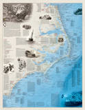
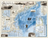
In the waters surrounding the Delmarva Peninsula, shipwrecks have become an ever presence hazard to mariners. Yet, the loss of galleons and frigates, pirates and privateers, sea raiders and merchantmen alike, have played an important role in shaping local and national history, maritime lore, and literature. Shipping losses in these waters have influenced laws, the course of countless wars, and the commerce of empires and nations. Since the first Europeans exploration of the mid-Atlantic seaboard, more than 4,000 vessels of every description have come to grief on the shoals and in the depths of these fabled waters. Whether caused by foul weather, mortal combat, bloody mutiny, treacherous bars, collisions, mechanical failure, human error, or myriad combination of all, most maritime disasters ended as only statistics. But in many ways, shipwrecks also represent humankind's will to struggle against all odds, and to prevail or perish in the effort. Indeed, for Everyman, they form the very fabric of history and high seas adventure that is without equal in any other environment.
History Beneath the Waves
A shipwreck has often been described as a historic time capsule. It dates back to the precise moment when the vessel was lost, and took with it the components of the society responsible for its construction and operation, evidence of tis service, and the cause of its loss. Through the discipline of marine archaeology and the scientific study of shipwreck remains in the 1970s, scientists have been able to plumb the depths of history to provide new insights into the regional and national maritime culture that helped shape our nation.
Maritime Dangers
Vessel losses in the Chesapeake Bay and along the coast of the Delmarva Peninsula have been attributed to many causes – floundering, fire, stranding, storms, ice, capsizing, explosions, collisions, mutiny, and navigational errors to name but a few. Pirates claimed victims at the entrance of the Chesapeake and Delaware Bays. The many military conflicts of America would see no less than 605 ships destroyed or sunk, including 5 war fleets, and scores of vessels scuttled as obstructions, prizes, or to prevent capture. Postwar fleet reductions would account for dozens more. Hundreds, and possibly thousands more, are believed to have been lost without record and with all hands.
Storms and Shoals
The shifting sands of Cape Henlopen, Delaware, and the trecherous, shoally entrance of Delaware Bay have possibly witnessed more maritime disasters than any similar geographic body in the United States. During just one single blizzard on March 12, 1888, no fewer than 25 vessels were driven ashore or lost between Rehoboth Beach and Lewes, Delaware. The following year, in September, a three-day-long hurricane claimed an additional 39 vessels.
Beacons for Safe Sailing
Hostile shores, invisible shoals, and migrating channels, in fair weather or foul, have inflicted the loss of countless vessels along with the untold lives of mainers sailing off the coasts of Delaware, Maryland, and Virginia. Beginning in 1767, with the erection of the first stone lighthouse on the sandy dunes of Cape Henlopen, and in 1791, with Congressional authorization for construction of the Cape Henry Lighthouse, man has sought to provide navigational aids and life-saving services to counter the dangers of the unforgiving sea and perilous coasts.
“The Taking of the City of Washington in America”
An engraving by G. Thompson, published on October 14, 1814, illustrates the actions of the British Expeditionary Force in capturing and destroying the American flotilla, the defeat of the American forces, and the burning of Washington.
The Ghost Fleet of Mallows Bay
Within a mile radius of Mallows Bay, beneath its green waters and shallows, lie the bones of the largest assemblage of wooden ships in the Western Hemisphere – once containing over 270 vessels dating from 1776 through the 1970s. Today, despite years of intensive scrap salvage following World War I, through the Great Depression, and to the early days of World War II, the skeletons of more than 125 vessels remain, many hidden beneath a shroud of trees and shrubs. Included are 88 wooden steamships, built between 1917 and 1923 for the U.S. Emergency Fleet Corporation at 41 shipyards in 17 states. Ten more lie submerged across the Potamac River at Widewater, Virginia.
“The Sinking of the U.S.S. CUMBERLAND”
This epic battle on March 8, 1862, marked the end of wooden fleets of war when the C.S.S. VIRGINIA (ex-U.S.S. MERRIMACK) came out on her maiden cruise to sink or destory the Federal blockade around Hampton Roads, Virginia. The U.S.S. CUMBERLAND was rammed at her Newport News Point station, and went down fighting to the last able cannon.
Brig-Sloop H.M.S. De BRAAK
Sunk on May 25, 1798, by a “sudden flow of wind” in Old Kiln Roads, Delaware Bay, all that remains of H.M.S. De BRAAK – the starboard hul – was raised and mearly destroyed in the process by terasure salvers on August 11, 1986. For the next four years the hull would remain in a specially constructed cofferdam, submerged in water, before being removed to a permanent conservation facility at Cape Henlopen. The recovery directly influenced the passage of the Abandoned Shipwreck Act of 1987.
World War I German submarine assault on the Atlantic seaboard between 1917 and 1918 inflicted heavy losses on Allied shipping, including 14 ships sunk off the coast of the Delmarva Peninsula. Yet, the German offensive served only to harden American resolve. Two-thirds of funds used during America's participation in the war were obtained through the sale of Liberty Bonds, popularized by graphic images ... The funds also helped build the U.S. Emergency Fleet that kept Europe supplied with food and war materials during its darkest days.
Operation Drum beat: Nazis on the Coast
On January 13, 1942, shortly after the United States entry into World War II against the Axis powers, Germany launched a submarine offensive against American shipping called Operation Paukenschlag – Operation Drumbeat. Thirty-five Allied vessels would fall victim to U-Boat torpedoes off the coast of the Delmarva Peninsula before war's end, many with sight of land.
FYI ~ DelMarVa is the portmanteau (a constructed word that combines both sounds and meanings) formed from the names of the states: Delaware, Maryland, and Virginia, that occupy the peninsula located between the Chesapeake Bay on the west, the Delaware River, Delaware Bay, and Atlantic Ocean on the east.