|
|
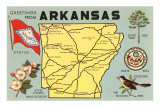
State of Arkansas Posters, Art Prints, Photographs, & Maps
for educators, home schoolers; themed decor in studio or office.
|
geography > NA > US > Southern States > ARKANSAS < social studies
|
|
Arkansas, known as the “The Natural State” joined the Union on June 15, 1836 as the 25th state. The Arkansas state motto is “Regnat populus”, The people rule.
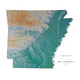
Arkansas, in the West South Central Region, has an eastern border of the Mississippi River with Tennesee & Mississippi, Louisiana to the south, Texas and Oklahoma to the west and Missouri to the north.
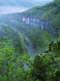
The geography of Arkansas extends from the northwestern mountainous Ozarks and Ouachita Mountains (US Interior Highlands) with the highest elevation, Mount Magazine, at 2,753 feet above sea level in the Ozark National Forest (Logan Co.). The lowest point is the Ouachita River at the border with Louisianna. The densely forested land in southern Arkansas, known as the Arkansas Timberlands leads eastward to the lowlands along the Mississippi River and the Arkansas Delta.
|
|
|
|
Highland forests of the Ozark Plateau and Quachita Mountains offer woods teeming with wildlife, streams and lakes with bass hiding in the shadows, and communities livened by square-dance and banjo-plunking occasions. The Arkansas River separates these two mountain regions as if flows southeastward to join the Mississippi on the eastern border. Fertile farmlands of the river valley rank Arkansas among the nation's leaders in cotton, soybean, and rice production.
If you're looking for mountain resorts, you can choose the quaint, quiet type such as Eureka Springs in the state's northwest corner, or perhaps a more cospmopolitan spa like Hot Springs with it baths, horse racing, and night life.
Throughout Arkansas – from Fort Smith, where the courtroom and gallows of the “hanging judge” Isaac C. Parker have been restored, to Helena's preserved antebellun homes in the cotton-rich delta country – you encounter the state's colorful past. Wending northeast ward from Clarksville through a time-forgotten countryside, State 123 provides a fine biking jaunt into the Ozark National Forest on a back road few tourists ever see. Petit Jean State Park southwest of Morrilton offers mountaintop appeal. Nearby are the late Governor Winthrop Rockefeller's Museum of Automobiles and his model farm, both open to visitors.
Lovers of mountain driving and truly spectacular scenery should consider touring south from Harrison on State 7. This scenic route takes you into the Boston Mountains, the most rugged part of the Ozarks. Another mountain excursion beginning at Harrison winds eastward on U.S. 62 to Yellville, then continues south on State 14 into Buffalo River country. The 132-mile-long Buffalo National River, guarded by majestic rock walls, is a canoeist's and fisherman's dream. Fishermen have little trouble finding an angling spot in the state's many lakes and more than 9,000 miles of streams.
Limestone brows overhaning fish-filled streams and contoured paddies where ducts and geese come to feed tally bench marks of Arkansas's charm. In woods where deer take cover and yellow jasmine blooms, mountain people keep alive folk music and revive old crafts – including carved caricatures of themselves that echo a mountain saying: “To keep the wolf from the door, howl less and whittle more.” Little Rock, the birthplace of Gen. Douglas MacArthur, beckons with a downtown restoration of historical buildings, some dating from the 1820s; down the river bearing the state's name Arkansas Post National Memorial recalls fur-trade days. Cannons at Pea Ridge mark where 26,500 men fought in the Civil War's most important battle west of Mississippi.
(poster text about Arkansas)
|
|
|
|
|
|
|
|
|
|
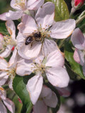
Apple Blossoms is the state flower for Arkansas and the Honey Bee is the Arkansas state insect.
The honey bee is important as a principal pollinator of crops and for producing honey. The apple tree is one of the most widely cultivated fruit trees, and the apple figures prominately in mythology, folklore and history.
• botany posters
• insect posters
|
|
|
|
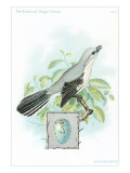
The Mockingbird is best known for its habit of mimicking the songs of other birds - mocking them. Mockingbirds eat berries, seeds and insects, prefer to perch in high places and will vigorously defend their nests. The Northern Mockingbird is the only mockingbird commonly found in North America and is also the state bird of Florida, Mississippi, Tennessee, and Texas.
• bird posters
|
|
|
|
Pine is the Arkansas State Tree. Almost all of Arkansas was forested with many different kinds of trees before the railroads made large scale logging operations profitable in the late 19th and early 20th centuries, leaving many areas “logged out.” Today there is more than 5 million acres of pine and mixed-pine forest in Arkansas.
• trees posters
|
|
|
|
|
|
|
Hot Springs is the oldest area currently in the National Park System – 40 years older than Yellowstone National Park. It was established by Congress as the Hot Springs Reservation on April 20, 1832 to protect hot springs flowing from the western slope of Hot Springs Mountain.
• more national parks posters
|
|
|
|
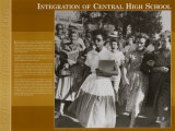
September 23, 1957 Integration at Central High School (Little Rock, AR)
Elizabeth Eckford was 15 years old when she helped integrate Central High School in Little Rock, Arkansas in 1957. When the Little Rock school board decided to allow a few black students into all white Central High, 80 African American students volunteered to integrate the school. School and local NAACP officials selected six girls and three boys from among the volunteers. They became known as the Little Rock Nine.
The night before school opened, the local NAACP president called to tell them to go to the school together. Because Elizabeth Eckford's family did not have a phone, she didn't get the message. Elizabeth went to the school alone.
On the morning of September 4, 1957, a crowd of white people gathered outside the school. Arkansas Governor Orvil Faubus had called out the state's National Guard to keep the black students from entering the school. Elizabeth Eckford walked steadly through a large crowd of jeering whites. At the school entrance soldiers blocked her way, and she was forced to walk back through the crowd. A little later, the other black students showed up and were also turned away.
News photographs showing Eckford surrounded by the angry students appeared around the world, embarassing the United States. Three weeks later President Dwight Eisenhower sent U.S. troops to Little Rock and put the Arkansas National Guard under federal instead of state control. The soldiers protected Elizabeth Eckford and the other eight black students when they entered Central High on September 23. U.S. troops and the National Guard kept order in the school for the rest of the year. The black students were called names and bullied at Central High, but they had opened the school doors for other African Americans.
• Black History posters
• 1997 - 40th Anniversary Desegregation Observances
• September 2007 - Commemorating 50 Years of Integration
• more History Through a Lens poster series
|
|
|
|
|
|
|
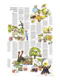
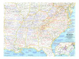
Battles of the Civil War Map from National Geographic shows battle sites with call-outs describing specific battles, dates, routes.
In Arkansas:
Ft. Smith changed hands several times during the Civil War. ... more ...
• Deep South Map
|
|
|
previous page | top
|
|
I have searched the web for visual, text, and manipulative curriculum support materials - teaching posters, art prints, maps, charts, calendars, books and educational toys featuring famous people, places and events - to help teachers optimize their valuable time and budget.
Browsing the subject areas at NetPosterWorks.com is a learning experience where educators can plan context rich environments while comparing prices, special discounts, framing options and shipping from educational resources.
Thank you for starting your search for inspirational, motivational, and educational posters and learning materials at NetPosterWorks.com. If you need help please contact us.
|
|
|