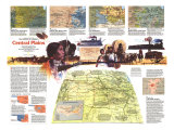
* Lesson plan idea - have your students update the information and latest statistics concerning the South Central states; discuss, contrast and compare the political, economic, and environmental situations the region is dealing with currently. • maps
Rich land of the southern frontier -
Robust individualsim of the frontier abides in the people of the South Central States. Cowboys, Indians, mountaineers, and bayou-dwelling Cajuns continue to characterize the area in legend and in fact.
Three sides etches by great waters – the Rio Grande, the Gulf of Mexico, the Mississippi – the region's geographical diversity includes citrus groves, cactus-pricked desert, forested highlands, and vast brown plains. Here grows a large part of the nation's cotton, rice, sugarcane, and cattle. But oil is the greatest source of wealth, accounting for more than half the total U.S. output.
For more than 450 years explorers, settlers, and travelers have molded the region. European exploration began in 1519 when Alonso Alvarez de Pineda, searching for a passage to Cathay, mapped the Gulf Coast. Today people whose heritage is Spanish or French, Indian or Mexican, African or Anglo-Saxon give the states their personality.
In every season, tourist are drawn to attractions as varied as the National Cowboy Hall of Fame in Oklahoma City, Houston's Astrodome, New Orleans's cuisine, and thermal baths in Hot Springs. Vacationists looking for something different might horseback Texas-style into Big Bend National Park, canoe on Arkansas's Buffalo National River, capture alligators and ibises on film in untamed Louisiana bayous, or even search for dinosaur bones in Oklahoma's once lawless Panhandle.
ARKANSAS - Highland forests of the Ozark Plateau and Quachita Mountains offer woods teeming with wildlife, streams and lakes with bass hiding in the shadows, and communities livened by square-dance and banjo-plunking occasions. The Arkansas River separates these two mountain regions as if flows southeastward to join the Mississippi on the eastern border. Fertile farmlands of the river valley rank Arkansas among the nation's leaders in cotton, soybean, and rice production.
If you're looking for mountain resorts, you can choose the quaint, quiet type such as Eureka Springs in the state's northwest corner, or perhaps a more cospmopolitan spa like Hot Springs with it baths, horse racing, and night life.
Throughout Arkansas – from Fort Smith, where the courtroom and gallows of the “hanging judge” Isaac C. Parker have been restored, to Helena's preserved antebellun homes in the cotton-rich delta country – you encounter the state's colorful past. Wending northeast ward from Clarksville through a time-forgotten countryside, State 123 provides a fine biking jaunt into the Ozark National Forest on a back road few tourists ever see. Petit Jean State Park southwest of Morrilton offers mountaintop appeal. Nearby are the late Governor Winthrop Rockefeller's Museum of Automobiles and his model farm, both open to visitors.
Lovers of mountain driving and truly spectacular scenery should consider touring south from Harrison on State 7. This scenic route takes you into the Boston Mountains, the most rugged part of the Ozarks. Another mountain excursion beginning at Harrison winds eastward on U.S. 62 to Yellville, then continues south on State 14 into Buffalo River country. The 132-mile-long Buffalo National River, guarded by majestic rock walls, is a conoeist's and fisherman's dream. Fishermen have little trouble finding an angling spot in the state's many lakes and more than 9,000 miles of streams.
Limestone brows overhaning fish-filled streams and contoured paddies where ducts and geese come to feed tally bench marks of Arkansas's charm. In woods where deer take cover and yellow jasmine blooms, mountain people keep alive folk music and revive old crafts – including carved caricatures of themselves that echo a mountain saying: “To keep the wolf from the door, howl less and whittle more.” Little Rock, the birthplace of Gen. Douglas MacArthur, beckons with a downtown restoration of historical buildings, some dating from the 1820s; down the river bearing the state's name Arkansas Post National Memorail recalls fur-trade days. Cannons at Pea Ridge mark where 26,500 men fought in the Civil War's most important battle west of Mississippi.
OKLAHOMA - During the 19th century, the hills and plains of Oklahoma – known as Indain Territory – became a reservation for tribes uprooted from homelands in the East. Today some 100,000 American Indians live in the Sooner State – so called after settlers who jumped the gun to stake claims in land rushes beginning in 1889, when the government opened the land for white settlement.
Anadarko's American Indian hall of fame honors such notable Indians as Sequoyah, who created the Cherokee alphabet, and Sacagawea, the Shoshone guide of the Lewis and Clark expedition. Nearby, Indian City, U.S.A., reconstructs villages featuring Pawnee earth lodges, Wichita grass houses, Plains tipis, and Apache wickiups.
In Comanche County, to the south, Wichita Mountains Wildlife Refuge preserves an island of the American West's virgin land. Here you can see a prairie dog town, and deer, elk, bison, and Texas longhorns roaming free. Venerable Fort Sill is right next door with its huge collection of artillery.
A tempting assortment of state parks also awaits the traveler. Many of these are located at man-made lakes. Two of the latter, Texoma and Eufaula, thrive as year-round playgrounds. On Poteau Mountain near Heavener as state park protects a great slab of rock carved with mysterious runic symbols.
Oklahoma City's capitol has the unique distinction of being surrounded by oil wells, one of which draws oil from beneath the building. Tulsa maintains its oil heritage with the international Petroleum Exposition, held every five years. With completion of the McClellan-Kerr Arkansas River Navigation System, Tulsa has gained a water route to the Gulf of Mexico and the Great Lakes.
The Chisholm Trail – which had its first cattle drive in 1867 – can be followed on U.S. 81. Rich wheat land rolls away to the horizon along the northern half of the route. In Ponca City a bronze statue by Bryant Backer pays tribute to dauntless pioneer women. Northwest of Boise city is the Panhandle – once an outlaws' refuge known as “No Man's land” – you can still see wagon-wheel ruts of the old Santa Fe Trail.
LOUISIANA - Sailing down the Mississippi in 1682, La Salle claimed a vast area, which included the present state, for France's Sun King, Loouis XIV. Today, Louisiana's premier tourist attraction is the Vieux Carre, better known as the French Quarter of New Orleans.
In spirit of its long-accepted name, the French Quarter's hundred blocks of Old World buildings, with leafy patios and balconies of iron grillwork, are more Spanish than French in design. And gastronomes assert that New Orlean's famous cuisine is not French but Creole – based on the spices of the delta, the bounty of the gulf, and the culinary arts of French, Indian, Spanish, and African cooks. And the music? Not French at all, but Dixieland jazz blaring every night from bistros on Bourbon Street. New Orleans, in its uniqueness, delights the eyes, ears, and taste buds of those fortunates who can sample its charms.
Rich in the fine antebellum homes, the stretch of the old River Roads that hugs the Mississippi from New Orleans to Baton Rouge meanders by such showpiece mansions as San Francisco Plantation house and the Houmas House. A skyscraper capitol in Baton Rouge stands as a striking counterpoint.
If you've brought your fishing gear, some of Louisiana's best freshwater angling spots await you in the northern half of the state. Toldedo Bend Reservoir on the Texas-Louisiana border abounds in bass, crappie, beam, and catfish. In the north, too, prehistoric indian mounds rise at Poverty Point, a notable archeological site near Epps. And Shreveport, northern Louisiana's largest city, each spring stages a ten-day festival of art and flower shows and contests.
Lafayette is the heart of Acadiana, or Cajun country as most call it. The people of this region – southern Louisiana in general – have a culture that intensely upholds the language, joie de vivre, and Catholic faith of their French forebears who came here in the 18th century after being expelled from Acadia, now Nova Scotia. A wooded state park north of St. Martinville commemorates the area's most enduring tale, the tragic story of separated Acadian lovers told by Henry Wadsworth Longfellow in Evangeline.
Vast fields extend from the highway as you travel through southwestern Louisiana's prairies, the rice belt. In spring irrigation turns fields into lakes, which during the growing season become green seas of grain. Fall changes them into a golden harvest. Crowley celebrates the bounty of October with a fair that includes rice-eating and rice-cookng contests.
To the east, New Iberia claims to be the sweetest, spiciest, and saltiest spot in the South. A visit here – with its proximity to extensive sugarcane fields, a hop-pepper-sauce works, and huge salt domes – could definitely enhance the flavor of a day's outing.
Wildlife refuges along the shore attest to the popularity of Louisiana's coastal marshes as wintering grounds for flocks of wild ducks and geese. Charter boats from Grand Isle and other costal towns will take you deep-sea fishing in the Gulf of Mexico.
TEXAS - Texas! So vast in area, so varied in terrain, so rich in human and natural resources, that it seems almost unfair to make statistical comparisons with most other states. For all its land area – 267,339 square miles – this largest of the contiguous 48 states has superlative highways to bind the wide-open spaces and make them accessible. Be prepared, however, for long drives on straight roads through unremarkable countryside where there is a tendency to drive too fast, and even to forget that you are driving at all.
Amarillo stands out as the center of the Panhandle's oil and gas industry and as one of the largest cattle markets in the United States. Lively public auctions are held each week at the Western Stockyards. Palo Duro Canyon, the Panhandle's masterpiece of erosion dazzles the eye with its rainbow-hued rock strata – a geological spectrum that took a million years to create.
In the western part of Texas lies a mountainous, big-sky area of desert beauty. Amateur archeologists will have fun exploring Monahans Sandhills State Park, near Odessa, some 4,000 acres of wind-ruffled sand dunes where Indian artifacts and bones of prehistoric animals have been found. Big Bend National Park encoompasses a wilderness of mountains and desert where the Rio Grande has sliced three towering canyons out of rock. The walls of Santa Elena Canyon rise 1,500 feet above the river. A rough but breath-taking boat trip awaits the skilled visitor bent on exploration. Rugged, too, is the challenge of Guadalupe Mountains National Park with its spectacular fossil reef and unique remnant of ancient forest thrusting from the desert. El Paso exudes the international flavor of a city that has another country in its backyard. Ciudad Juarez – Mexico's fifth largest city – entices with bargain-filled shops, nightclubs, horse and dog racing, and bullfights. If you plan on driving across the border here or at other crossings long the 1,250-mile Texas-Mexico frontier, you should be aware of car insurance and customs regulation; they change from time to time. For tourists going to border towns for three days or less, neither government requires special inoculation of out-of-ordinary indentification.** research for most current regulation.
The vitality of Houston – the state's largest city and sixth ranking in the United States – dominates a damp region of bayous, rice fields, farmland, and pine forests. Northeast of sprawling Houston you can choose to explore no fewer than four national forests. There also the primeval Big Thicket region spreads its wild botanical treasure of oaks, orchids, hollies, pines, and ferns. On the Thicket's northern edge the Alabama-Coushatta Indians have a reservation.
Natural wonders run into stiff competiton for the vacationists' time in the culture-rich Dallas-Fort Worth area. But if you're curious about oil wells, try Kilgore, right in the middle of the vast east Texas field. Here more than 300 producing rigs jut from the town's every nook and cranny. If you wonder where the oil goes after it leavs the ground, many of the state's 190 refineries offer tours.
The special charms of San Antonio find some explanation in the flags it has grown under: Spain, Mexico, the Republic of Texas, the Confederacy, and the United States. Jackrabbity hill country unfolds to the northwest and northeast of San Antonio. Around Bandera and Kerrville dude ranches and hunting preserves dot the countryside. Lakes and caves highlight the settings of New Braunfels and Austin.
U.S. 83 from Laredo to Brownsville takes you past roguish south Texas border towns and lush citrus groves an vegetable fields. Padre Island National Seashore – a beachcomber's paradise – covers 80 miles of 113-mile-long Padre Island, which parallels the coast from Port Isabel to Corpus Christi.