|
|
|
|
|
|
|
|
|
|
|
|
GEOGRAPHY TEACHING RESOURCES
|
|
|
|
|
|
|
|
|
|
|
|
|
|
|
|
|
|
|
|
|
|
|
|
|
|
|
|
|
|
|
|
|
|
|
|
|
 |
|
|
|
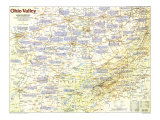
Ohio Valley Poster Map - Making of America, 1985
for the geography and social studies classrooms and home schoolers.
|
geography > North America > United States > Midwest > OHIO VALLEY MAP < history < social studies < maps
|
The 1985 Ohio Valley map Side 2 features:
• A historical overview of the region
• Six maps detailing the history of the region with information on aboriginal cultures, speculation and colonization, Indian removal, farming, Civil War conflicts in the region, coal mining, modern industries and more
• Text about each historical period illustrated
• Colorful illustrations
|
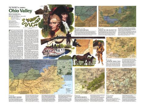
Ohio Valley Poster Map,
National Geographic, 1985, side 2
Kentucky, Tennessee, West Virginia, southern Ohio, southern Indiana, southern Illinois, western Virginia, eastern Missouri, northern Mississippi, northern Alabama, northern Georgia, western North Carolina
|
|
* Lesson plan idea - have your students update the information and latest statistics concerning the Ohio Valley states; discuss, contrast and compare the political, economic, and environmental situations the region is dealing with currently. • maps
FYI - Thomas Jefferson said “The Ohio is the most beautiful river on earth. Its current gentle, waters clear, and bosom smooth and unbroken by rocks and rapids, a single instance only excepted,” The name Ohio is from the Seneca, meaning “good river”.
FRENCHMEN were first to claim the Ohio River, in the late 1600s, yet decades passed before France sought a firm hold over the great waterway. By the early 1700s pro-British Iroquois had pushed westward into the upper Ohio Valley, and French fur traders and missionaries had carved toeholds along the Mississippi. To link the Great Lakes and the Mississippi, the French skirted the Iroquois, using the Wabash and the Illinois Rivers instead of the Ohio. A handful of garrisoned missions and trading posts in the Illinois country helped define a crescent-shaped French axis from Montreal to New Orleans, weakly binding Canada and Louisiana.
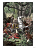
A violent struggle for the river embroiled the Indians when the British turned their attention to the region, and in 1755 Maj. Gen. Edward Braddock's army was crushed near Fort Duquesne (built at a point where the Allegheny and Monongahela rivers come together to form the Ohio). When Britain eventually won control of the forks of the Ohio three years later, France lost what a Canadian governor had described as the “main conveyance from Canada to the River Mississippi.”
In 1763, at the close of the French and Indian War, Britain drew a line temporarily barring colonization west of the Appalachians. By the outbreak of the American Revolution in 1776, pioneers were spilling into Ohio Valley. Tribes resisted the influx, and whites sought safety in fortified stations supplied overland from the eastern seaboard. The Greenville Treaty of 1785, which involved vast Indian land cessions to the United States government, assured settlers safe passage west on the river. The Ohio territory held enough people to earn statehood in 1803, when the Louisiana Purchase guaranteed river access to the vital outlet of New Orleans.
Another surge followed the War of 1812. Handbooks advised that Kentucky's “best land are sold” and promoted the new states of Indiana and Illinois. Antislavery farmers – among them Pennsylvania Germans, Scotch-Irish Presbyterians from upland Virginia, and Kentuckians – settled north of the Ohio. After 1830 New Yorkers and New Englanders, coming via the Erie Canal and the Great Lakes, increased northern opposition to slavery. Making backwaters of the canals in the 1850s, railroads redirected farm trade the spurred the growth of industrial cities.
With the rural south and the industrial North deadlocked over slavery and state's rights, the nation began to divide against itself in late 1860. By March 4, 1861, when Kentucky-born Abraham Lincoln was inaugurated, the cotton states had seceded. War erupted in April. In early 1865 the Confederate South finally succumbed. Some 600,000 Americans had died.
North-South economic differences intensified in the region after the war as railroads expanded the nation's industrial heartland from the Great Lakes to the Ohio. Timber barons and coal kings plundered the southern Appalachians, siphoning out profits. Jobs in Pittsburgh's iron-and steel-making complex and other industrial centers drew mountaineers and, with World War I, many blacks from a life close to the land.
In an era of federal involvement the Tennessee Valley authority began countering economic depression in 1933. The controversial Appalachian Regional Commission, established in 1965, stimulated development with new roads. Reversing a post-1940 exodus, more people came to Appalachia in the 1970s than left for the industrial North.
This human tide has ebbed and flowed across the Ohio River, a conduit of early westward expansion and long a commercial artery.
1. CA 1000 B.C. - A.D. 1760 - INDIANS AND EUROPEANS - MISSIONARIES from Quebec settled in 1699 at Cahokia, site of a former Indian metropolis, and Illinois country became the midriff of French North America.
SCOUTING FOR SPECULATORS - In the mid-1700s Thomas Walker entered Kentucky via the Cumberland Gap for the Loyal Land Company, and Christopher Gist explored the Ohio Valley for the Ohio Company of Virginia.
ABORIGINAL CULTURES - Some 3,000 years ago the Adena people began bulding conical grave mounds. Hopewellians came next, traders who left behind huge geometric earthworks and many burial mounds, followed by Mississippian farmers, who made flat-topped temple mounds. Their culture had faded by the time the French arrived at Cahokia.
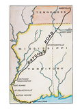
2. 1760-1815 - SPECULATION AND COLONIZATION - IN 1775 Judge Richard Henderson's Transylvania company sent frontiersman Daniel Boone to cut a trail into Kentucky. His trace became the Wilderness Road. Many of the region's Indian and pioneer routes followed game paths that connected salt licks, often the nuclei for towns, such as Nashville. Settlers surged in from the mid-Atlantic region, and Kentucky's population, concentrated around Lexington in the Bluegrass country, rose from some 100,000 at statehood in 1720 to more than 220,000 by 1800. Many who came to Tennessee, made a state in 1796, chose the Nashville basin. Massachusetts speculators formed the Ohio Company of Associates and found Marietta in 1788, and for a time Ohio's newcomers stayed close to the river.
Easterners floated down from Pittsburgh and Wheeling in crude flatboats, disembarking at river-road junctions such as Maysville, Cincinnati, and Louisville. Zanesville and other towns blossomed where roads met navigable tributaries. Flatboats carried produce – ranging from flour, whiskey, and salt-cured pork to tobacco and hemp – downstream to New Orleans. Boatmen returned overland along the Natchez Trace.
EVOLVING RIVER CRAFT - Canoes gave way to flatboats - known as Kentucky and New Orleans boats as well as arks and broadhorns. Unlike flatboats, more streamlined keelboats could be negotiated upstream. The first streaboat navigated between Pittsburgh and New Orleans in 1811-1812.
LAND ORDINANCE OF 1785 - In 1785 Thomas Hutchins began surveying the first seven ranges of townships in the Old Northwest Territory. Subsequently the so-called rectangular survey system, under which lands were divided into township tracts six miles square and sudivided inot 36 640-acre sections was applied to all U.S. public lands.
NORTHWEST ORDINANCE OF 1787 - Formulated when frontier areas were clamoring for statehood – including the region seeking admission as the state of Franklin – the ordinance provided for the creation of territories and their subsequent entry into the Union on equal footing with the first states. Among other fundamental principles, it banned slavery in the Northwest Territory.
3. - 1815-1860 - TRANSPORT REVOLUTIONS - “STEAM IS CROWDING our eastern cities with western flour...,” wrote an observer in 1841. Steaming from New Orleans to Louisville in days versus the keelboat's month, paddle wheelers set river towns on a growth course. In 1825 New York's Erie Canal sparked a frenzy of state-sponsored canal building, often at crippling costs. Soon the Ohio Valley was linked by water to New York City via the Great Lakes. Canals boosted land sales and, by forcing down freight rates, fostered commercial farming in Ohio, Indiana, and Illinois. Built piecemeal, the National Road to Vandalia, Illinois, offerd shippers of eastbound goods a poor alternative to canals and the sea route via New Orleans.
ANTEBELLUM FARM ECONOMIES - Although mixed farming of corn, bogs, and hay was widespread, varied crops and methods reflected physical, cultural, and economic differences between South and North. Slave-operated plantations in Kentucky raised hemp and tobacco, and by the 1820s large cotton plantations had spread into Tennessee. Railroads helped make Illinois the leading wheat state by 1860.
REMOVING INDIANS - President Andrew Jackson's 1830 Removal Act forced tribes west as settlers grabbed their lands. Mass relocation of the Cherokee took place in the winter of 1838, but a small band fled to the mountains of North Carolina. In Ohio, Indians ceded one area after another to the U.S., the last in 1842 by the Wyandot.
4. - 1860-1865 - REGION RENT ASUNDER - CONSIDERED essential by Southerners but increasingly opposed by Northerners, slavery became a catalyst for disintegration, and the Ohio Valley was the seam along which the young nation ripped apart west of the mountains. Beginning with South Carolina in December 1860, seven Deep South states seceded by February 1861, soon followed by Virginia, Arkansas, North Carolina, and Tennessee, The slave states of Kentucky – neutral at first – and Missouri remained in the Union but were riven by guerrilla warfare. Oriented toward the Ohio Valley, 48 northwest Virginia counties entered the union as West Virginia in June 1863. There upland subsistence farmers, long at odds with powerful Tidewater planters, had opposed Virginia's secession.
In the vast western theater, rivers and railroads dictated strategy. Union troops coursed down the Ohio and Mississippi Rivers to battlegrounds in Kentucky, Tennessee, and Mississippi. The early loss of Forts Henry and Donelson cost the Rebels the Tennessee and Cumberland Rivers, gateways to the Deep South. Confederate generals rallied troops at major rail centers. After Nashville fell, Corinth, Memphis, and Chattanooga capitualted, cracking the Memphis and Charleston Railroad, the “vertebrae of the Confederacy.” The surrender of Knoxville along the Chattanooga gave the Union another key rail line, the Virginia and Tennessee. Meanwhile, the Union had won control of the Mississippi through victories at Vicksburg and Port Hudson, splitting the Confederacy and choking off its lifeline to the West.
Although it reached its final conclusion in the East, the Civil War was largely won west of the Appalachians, where Union Brig. Gen. William Tecumseh Sherman had predicted that whoever “gets the control of the Ohio, Mississippi, and Missouri Rivers will control the continent.”
UNION ADVANTAGES - On the eve of the Civil War the 23 Union and Border States had more than 20 million people; the 11 Confederate States 9 million, 3.5 million of them slaves. The North produced 37 times as much coal and 15 times as much iron. It had more than three-quarters of the nation's factories, more than two-thirds of the railroad mileage, most of the banking capital, and overwhelming naval supremacy.
REBELLION WITHIN A REBELLION -The mountains of eastern Tennessee harbored many Unionists who either enlisted with the North or joined marauding guerrilla bands.
SHILOH, APRIL 6-7, 1862 - In a near defeat for the North, the Federals suffered more than 13,000 casualties and the Confederates nearly 11,000. The battle, fought near Pittsford Landing, dashed all hope of a quick and easy outcome.
ROOTS OF ANTAGONISM - The slave-importing plantation was as vital to the southern economy as the manufacturing plant was to the northern. Heavily dependent on export markets, the South opposed federal tariffs, while the industrializing North accepted federal intervention.
CRUSHING THE CONFEDERACY - Grand master of strategy, Lt. Gen. Winfield Scott conceived the so-called Anaconda Plan. This entailed dividing the South along the Mississippi and strangling it by coastal blockade, “so as to envelop the insurgent states.”
SOUTHERN RAILROADS - Vulnerable to attack down its broad river valleys, the Confederacy depended on inadegquate, poorly run railroads. Only two major lines linked east to west and north to south. Its few regional lines, often built at different gauges, belonged to competing companies, and the South had almost no industrial capacity to replace track and rolling stock.
EMANCIPATION PROCLAMATION - On January 1, 1863, President Lincoln issued his Emancipation Proclamation declaring slaves in the rebellious states “thenceforward, and forever free.” Slavery continued, however, in the Border States of Missouri and Kentucky and elsewhere until outlawed in 1865.
WHERE SOUTH MEETS NORTH - As a border zone, the Ohio Valley region shows the cultural and economic imprint of both South and North. The top line marks the northern limit of southerness; below it, a significant proportion of the 1850 population had southern origins. The cotton-growing area represents the Deep South, the core of slavery-dependent southern culture.
5. 1865-1930 - FURTHER DIVERGENCE - AFTER THE WAR iron ore from St. Louis went up the Ohio and coal came down, as steamboats enjoyed a second heyday until overtaken by railroads in the 1880s. By the 1890s farm machinery ws rolling out of the Ohio and Illinois; after 1900 automobile factories geared up in Indiana and Ohio. Coal from around Connellsville, Pennsylvania, helped forge an iron-and-steel empire that produced more than two-thirds of the nation's steel by 1914.
In the mostly rural South, industry concentrated in a few cities such as Nashville, Chattanooga, and Louisville, whose population nearly doubled, to 308,000, between 1890 and 1930. Although old staple crops persisted, emancipation etched new patterns of subdivided estates, tenancy, and crop diversification. Blooded livestock and white burley tobacco made the Bluegrass a profitable region.
MULE POWER - Deep South cotton growers relied on mules – sturdy, efficient, and long-lived animals – bread in Missouri, the Bluegrass, and the Nashville basin and acquired at markets such as Columbia, Tennessee.
MOUNTAINEERS BECOME MINERS - Southern Appalachia's people were originally self-sufficent farmers whose folk culture bore the stamp of an isolated, rugged land. But railroads fostered lumbering and coal mining, and in the early 1900s mountaineers flocked to hundreds of company towns, most of them drab, some squalid. A slowdown in mining in the 1920s encouraged out-migration.
COAL REGION - Blacks and eastern Europeans joined workers in mines that produced nearly four-fifths of the nation's bituminous coal. By 1930 Pennsylvania and West Virginia were each producing almost 150 million tons, Kentucky and Illinois 61 million each, and Ohio and Indiana about 20 million each.
** compare the declining use of coal as fuel for generating electricity with the switch to using natural gas and the environmental problems associated with fracking to extract the natural gas.
6. 1930-PRESENT - A NEW ERA - ON MAY 18, 1933, Congress created the Tennessee Valley Authority, charged, as President Franklin D. Roosevelt envisioned, with “planning for the proper use, conservation, and development” of the 40,000-square-mile river basin. With 46 dams, the TVA generates power, controls flooding, improves navigation, provides recreation, and aids soil conservation.
World War II brought industries such as chemicals to the TVA region and the Ohio Valley. The postwar years saw many Southerners enticed from farms and small towns below the Ohio by jobs in far-off cities and others forced from mines by mechanization. The recent drift back to the land has helped reverse the flow, and the upper South – accessible and offering relatively inexpensive labor – lures automobile and other manufacturing.
COMMERCIAL LIFELINE - Navigation improvments have helped assure the Ohio River's continuing commercial role. The Ohio carries 150 million tons of cargo – more that seven times that of the Hudson – consisting mainly of coal but also of sand and gravel, corn, and chemicals.
THREAT TO LAND AND CULTURE - Appalachian hill farmers resent the loss of land over the years to the U.S. Forest Service, the National Park Service, the TVA, corporations, and absentee owners. They fear that newcomers will further unravel their traditional culture, knit by religion and family.
|
|
|
|
|
previous page | top
geography > North America > United States > Midwest States > OHIO VALLEY MAP < history < social studies < maps
|
|
I have searched the web for visual, text, and manipulative curriculum support materials - teaching posters, art prints, maps, charts, calendars, books and educational toys featuring famous people, places and events - to help teachers optimize their valuable time and budget.
Browsing the subject areas at NetPosterWorks.com is a learning experience where educators can plan context rich environments while comparing prices, special discounts, framing options and shipping from educational resources.
Thank you for starting your search for inspirational, motivational, and educational posters and learning materials at NetPosterWorks.com. If you need help please contact us.
|
|
|