* Lesson plan idea - have your students update the information and latest statistics concerning the South; discuss, contrast and compare the political, economic, and environmental situations the South is dealing with currently.
• maps
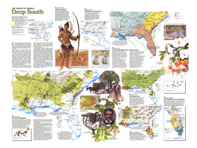
Deep South Map text - Corn, not gold, greeted Spanish explorer Hernando de Soto in 1539 when he landed in Florida in search of treasure. Across the South, he found teeming communities of Mississippian Indians, their cornfields whispering of riches in the soil.
Spain wanted a secure Florida to protect treasure fleets homeward bound from Mesoamerica. Beginning in 1565 – 52 years after Ponce de Leon sailed the coast – the Spanish held sway from St. Augustine. Then in 1682, as English fur traders ventured west from Charles Town, France claimed the mouth of the Mississippi River.
Competing Europeans courted Indians, depleted by disease and warfare, as allies and trading partners. By 1710 the British had razed every Spanish mission. France's Louisiana languished, while Britain's Carolinas prospered under a plantation system based on slavery.
After the Revolution, cotton ignited a land rush by whites that drove some 90,000 Indians westward, including 16,000 Cherokees along the Trail of Tears. By 1860 cotton reigned from North Carolina into Texas, sustained by slaves whose numbers had swelled from nearly 250,000 in 1790 to about three million.
Following the Civil War, most black freedmen returned as sharecroppers to subdivided plantations; eventually many landless whites also became sharecroppers. Cotton ruled again, peaking in 1914, but the growth of textile mills and small cities began to alter the economy. Wartime military spending and the later space program stimulated manufacturing and light industy. Farmers diversified crops or left for the city. Several million blacks streamed north. But in the 1970s and 1980s – for the first time since the Civil War – more blacks entered the South than left.
Tens of millions of tourists pour into Florida each year, swamping the resident population. As the the 21st century draws near, high technology rubs shoulders with resorts along Florida's southeast coast, promising a new prosperity.
I - AD 1000-1543 - INDIAN LEGACY -
Indians of the Southeast shared a subtropical farming culture, perhaps derived from Mesoamerica, based on corn, beans, and squash. From well-defended villages, such as palisaded Chiaha and moated Pacaha, Indians traded from the Gulf to the Great Lakes. Their huge earthen mounds supported temples and chiefs' houses. More delicate artifacts as shell ornaments and decorated pottery from such sites as Ethowah in Georgia.
II - 1543-1700 - IMPERIAL FOOTHOLDS -
The viceroyalty of New Spain laid claim to the continent's southern tier, but England's Charles II granted a charter for an ocean-to-ocean territory to the proprietors of Carolina in 1663. He expanded it in 1665. France, failing in Florida in the 1560s, achieved a foothold on Biloxi Bay in 1699. Indians still controlled the interior.
III - 1700-1783 - THREE EMPIRES AND THREE RACES -
Hard times sent Barbadian sugar planters to the Carolinas in the late 1600s. After trial and error, these and other settlers chose rice as their staple, establishing plantations societies on the fertile wetlands of the Carolina-Georgia tidewater. Charleston, Savannah, and New Orleans evolved as social and commerical centers.
Some planters brought slaves with them from the Caribbean. Most, however, purchased Africans from Angola, Ghana, and elsewhere in western Africa. A minority in 1700, blacks in South Carolina outnumbered whites by two to one within 30 years.
Many planters, new to the difficulties of growing rice, relied on those slaves familiar with the finicky plant. In 40 years South Carolina's production soared more than a hundredfold. After 1750, indigo supplemented rice. Thriving on drier soils, the dye crop carried plantation culture inland.
In the early 1700s tens of thousands of Scotch-Irish and Germans moved south to Carolina's interior lowlands and backcountry. Displacing Indians, they carved out tracts to raise corn, wheat, tobacco, cattle and hogs. English and small groups of Swiss and French Protestants landed on the coast. Highland Scots spread inland up the Cape Fear River. By 1725 German farmers had settle in the lower Mississippi Valley. And in the 1760s Acadians, later called Cajuns, arrived from Nova Scotia.
IV - 1783-1865 - COTTON KINGDOM -
Eli Whitney's cotton gin of 1793, varieties of cotton suited to the uplands, the collapse of the indigo market, and the insatiable demand of Britain's textile industry accelerated the boom. Planters and slaves from the coastal districts around Charleston and New Orleans soon established cotton on virgin upland tracts. By 1820 other cotton regions had sprouted in Tennessee and Alabama.
Greed for land force the Indians out, and settlers swarmed into their ancestral territories. Production soared in the black belt – the rich, dark-soiled heartlan of the expanding cotton kingdom. Many small-acreage farmers rose into the ranks of large landowners.
Also pushed out by cotton, pioneer stockmen of the Carolinas backcountry eventually reached northeart Texas, taking with them their open-range cattle-hering tradition. Others spread southwest into the sandy piney woods.
Cotton-bearing wagons converged on such fall-line depots as Columbia, Augusta, and Macon. Flat-bottomed “cotton boxes” floated downriver to seaports. By 1860 local railroads, such as the Vicksburg and Jackson, linked various production areas with major waterways.
Most slaveholders owned fewer than five slaves, and most farmers had none. Yet by 1860 large plantations with at least 20 slaves contributed more than one-third of the four-million-bale crop – on less than a quarter of the improved land. A world unto itself, the cotton plantation, centered on the handsome “big house” with its service buildings and rows of slave quarters behind, has come to epitomize antebellum southern culture.
V - 1865-1940 - POSTBELLUM -
After Reconstruction, northern capital, local cotton, and plentiful labor fostered a piedmont textile industry. In the early 1900s lumber milles devoured forests. By 1938 city jobs and the ravages of the boll weevil had propelled more than a million blacks north. New Deal policies encouraged remaining farmers to diversify their crops.
VI - 1940 - (1983) PRESENT - NEW DEEP SOUTH
Two-thirds rural in 1940, the region is now nearly two-thirds urban, with rapidly expanding metropolitan centers. Population of the nine states jumped from 23 to 42 million, but unevenly. Florida's 414 percent growth dwarfed Mississippi's 15.