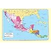
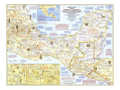
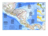
THE HEART OF MIDDLE AMERICA, called Mesoamerica, includes portions of Mexico and Central America that were occupied before the Spanish Conquest by highly advanced peoples who shared elaborate religious systems, a complex calendar, and – in many instances – hieroglyphic writing, mathematics, and astronomy. ...
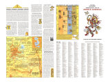
THE FEATHERED SERPENT - QUETZALCOATL
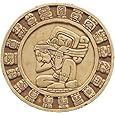
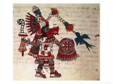
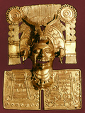
No figure looms larger in Middle American mythology and history than Quetzalcoatl, whose name means “feathered serpent” in Nahuatl, the language of the Aztecs. Central Mexicans honored him as the hero-god who not only created mankind with his own blood, but granted man the gift of corn, and thus civilization. In the tenth century A.D., the bearded Toltec priest-ruler Ce Acatl Topiltzin took the name of this revered god and initiated the golden age of Tula, his capital. Soon expelled by the militant magician-priests of rival god Tezcatlipoca, the man Quetzalcoatl, some legends say, made his way to the sea and disappeared to the east on a raft, vowing to return and reclaim his rule. At this time Maya chronicles not the arrival in Yucatan of Kukulcan, which means “feathered serpent” in Maya. A blend of man and god, Quetzalcoatl appears with various names and in different guises in pre-Conquest sculpture and hieroglyphic books. Aztec tradition predicted the return of bearded Quetzalcoatl the very year that Cortes landed. Thus were the Aztecs – and eventually all Mexico–defeated in part by their own folklore.
TIME PERIODS AND DATES -
The map notes emply three terms for the general dating of sites or events since 2000 B.C.: PRECLASSIC applies ot the time span from 2000 B.C to A.D. 900 to the Spanish Conquest. ... Dates recorde in the the Long Count, or five-place notation, by the Maya of the Classic Period, while accurate relative to one another, have not yet been positively matched with dates of the Christian Era. This map, in keeping with the preference of most authorities, uses the Goodman-Marinez-Thompson Correlation. An alternate correlaton, the Spinden, would make the Christian equivalent of each Long Count date about 260 years earlier.
LA HUASTECA - Area named for Maya-speaking Huastecs who have occupied it since pre-Conquest times, the cultural climax of the Huasteca, in the Early Postclassic Period, is characterized by large stone figures of chieftains or priests, the reverse sides of which are often carved with a death image of the individual.
THE TOLTECS - In the tenth century A.D., a people later called Toltecs, an obscure blend of northern nomads and civilized Mexican groups, became Middle America's greatest power. Though the Toltec state had waned by 1200, its miltaristic character remained the ideal throughout late Postclassic times, and its greatness had become legend when the Spanish arrived.
THE MAYA HIGHLANDS - The Late Precassic culture of highland and coastal Guatemala included the Izapan art style, hieroglyphic writing, and Long Count dating – prototypes of elements that distinguish later Lowland Maya civiliation. In the Early Classic Period, however, central Mexican influences hybridized this earlier culture. The highlands remained, until the Conquest, an area more Mexican than Maya in flavor, overshadowed by the enormous richness of the great Maya civilization to the north.
LOWLAND MAYA CIVILIZATION - The Yucatan Peninsula and its broad base near the mountains of Guatemala and eastern Chiapas formed the vast lowland stage upon which Maya civiliation rose, flourished and declined. The gradual blending of elements that comprised Maya culture crystallized around the third century A.D. into a high civiliation that, despite regional variations, was marked by a distinctive art style; the use of the corbelled vault; advance mathematical concepts, including the use of zero; a complex calendar; and the New World's most advanced writing system. For reason yet unknown, Maya civilization in the south disintegrated around A.D. 900. In northern Yucatan it merged with Postclassic Mexican culture, only to decline a century before the Spanish arrived.
CLASSIC VERACRUZ CIVILIZATION - Central Veracruz became the focus of Mexican civilization in the Late Classic Period, between the fall of Teotihuacan and the rise of Toltec militarism. The hallmark of classic Veracruz culture is its sculpture, distinguished by interlocking scroll motifs, largely devoted to stone “yokes” and other objects associate with the ceremonial ball game.
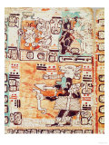
MAYA CODICES - Three Maya hieroglyphic books that survived the Conquest of Yucatan are among the library treasures of Dresden, Madrid, and Paris. In varying states of completion, they contain rituals and prophecies connected withthe passage of time, astronomical tables, with passages related to good and bad luc in daily activities.
MIDDLE AMERICA'S SOUTHERN FRONTIER - Within the broad band of land that includes western Honduras and El Salvador, Middle America's pre-Spanish culture merged with that of peoples to the southeast. Prelassic and Classic Period sites in the western part of this marginal zone reflect the fluctuation of history in the Maya area; those to the east show little or no Maya influence. In Postclassic times, a central Mexican group, the Pipil, occupied the whole area and extended Middle America's cultural frontier along the Pacific coast as far as Costa Rica.
GUERRERO - Archeologically, Guerrero is one of the least explored of the areas that comprise the Middle American heartland. Scattered finds indicate occupation from Preclassic times onward, with particularly strong evidences of art in the early Olmec style and Classic Period material related to Teotihuacan civilization.
MIXTECA-PUEBLA ART - Craftsmen of the great center of Cholula blended Mixtec and Aztec traditions into the distinctive Mixteca-Puebla art style of the Late Postclassic Period. Their products included brilliantly colored pottery, gold-work, and turquoise mosaics.
OLMEC ART AND RELIGION - Eight National Geographic Society -supported expedition between 1938 and 1946 were the first to reveal the full splendor of this remarkable Gulf Coast culture of the first millennium B.C. The distinctive Olmec art style is pervaded by an obscure but powerful religion dominated by sky or rain deities in the form of jaguar people, with drooping or snarling feline mouths and deformed heads.
ZAPOTECS AND MIXTECS - These two peoples in turn dominated the pre-Conquest history of Oaxaca. Zapotecs, centered at Monte Alban, blended early influences from the Gulf Coast and Teotihuacan to reach their cultural climax in the Classic Period. Post classic expansion of Mixtecs from the western mountains dominated the Zapotec heartland by the 14th century. Aztec attempts to subjugate the Oaxaca area never succeeded.
POPUL VUH - The Popul Vuh, or Sacred Book of the Quiche Maya, survives in a 17th-century copy. It contains the myths, traditions, and history of that great people up to A.D. 1550, and ranks as one of the major literary achievements of native America.
TEOTIHUACAN -
MONTE ALBAN -
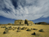
CHICHEN ITZA - OLD CHICHEN, the southern portion of Chichen Itza, popularly called “Old Chichen”, includes several major groups of ruins. One of them contains the only Long Count date known for the site, equated to A.D. 879.
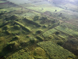
TIKAL- Intensive construction at Tikal continued from late Preclassic times until the disintegration of Classic Maya civilization around A.D. 900. More than 3,000 separate constructions, many of them simple dwellings, lie within the six-square-mile heart of the ruins surveyed so far. Beneath lie an estimated 10,000 earlier structures. The whole city may once have covered an area of 25 square miles.