|
|
Guatemala & Guatemalan Culture Posters, Prints, Charts, & Maps
curriculum enrichment resources for classrooms.
|
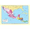
geography > North America > Central America > GUATEMALA < social studies
|
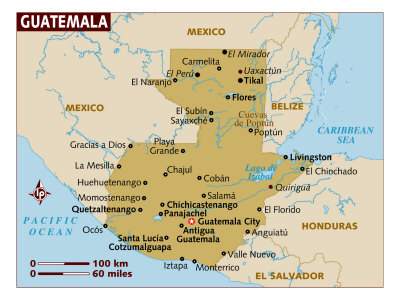
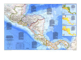
The Republic of Guatemala is located in Central America, bordering the the Gulf of Honduras (Caribbean Sea) between Honduras and Belize, and the North Pacific Ocean, between El Salvador and Mexico.
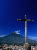
Guatemala is mostly mountains, has narrow coastal plains, and a rolling limestone plateau. The climate of Guatemala is tropical - hot and humid in the lowlands and cooler in the highlands. Like other Central American countries Guatemala is susceptible to hurricanes, volcanic eruptions and violent earthquakes.
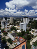
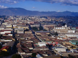
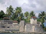
Guatemala City, is the capital of Guatemala, replacing the old capital of Antigua that was destroyed by the Santa Marta earthquakes of 1773. Earthquakes in 1917/18, 1976, and 2010; and the nearby volcano Pacaya, threaten the citizens of Guatemala City.
Guatemala and the surrounding area were home to the Maya for almost 2000 years before the arrival of the Spanish in the the early 1500s. Guatemala won independence from Spain in 1821, was briefly part of Mexico, and then a member of the United States of Central America federation that was destroyed by civil war. Guatemala has had a variety of military and civilian governments as well as a 36-year guerrilla war during the second half of the 20th century. With more than 100,000 people dead, and some 1 million refugees, the government signed a peace agreement in 1996.
One of the most notable archeological sites in the Americas, the ancient Mayan city of Kaminaljuyu, has been surrounded by the growth of Guatemala City.
|
|
|
|
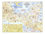
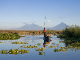
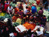
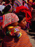
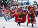
Guatemala - Nearly half the inhabitants of Central America's most populous country are directly descended from the Maya whose fabled civilization flourished here in pre-Columbian times. In the shadow of the skyscrapers on Guatemala City – Central America's largest urban center – Indian farmers tend the land following the traditions of centuries. This rural population is sharply divided from relatively prosperous city dewllers by economic and cultural barriers. With little hope of owning land and seeking to escape the continuing political violence, more than 40,000 Guatemalans have fled north into Mexico. Elections held in 1985 promise the diminishing of Guatemala's powerful military rule. (Text and statistics as of 1986.)
|
|
|
|
|
|
|
|
|
|
|
|
|
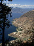
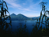
Aldous Huxley called Lago de Atitlán one of the most beautiful lakes in the world. A 7.5 earthquake in 1976 created a fracture in the lake bed that caused the water level to drop two meters in one month; 26,000 people died in the earthquake. An eruption and earthquake in September 1541 killed Beatriz de la Gueva de Ubeda, the Spanish govenor of Guatemala who had succeed her husband Pedro de Alvarado.
• more volcano posters
• lakes posters
|
|
|
|
|
|
|
|
|
|
|
|
| A huipil is a tunic / blouse made from rectangular strips of cloth joined together. The huipil has been worn since by indigenous women in southern Mexico and northern Central America since ancient Mayan times. |
|
|
• more food posters
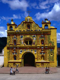
• more architecture posters
|
|
|
|
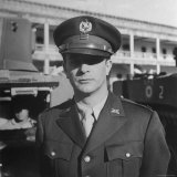
Jacobo Arbenz Guzman
Guzman (1913–1971) was president of Guatemala from 1951 to 1954, when he was ousted in a coup d'état organized by the U.S. Central Intelligence Agency, known as Operation PBSUCCESS, and was replaced by a military junta headed by Colonel Carlos Castillo Armas.
|
|
|
|
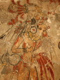
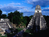
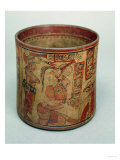
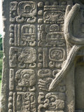
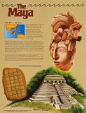
The Maya
(500 B.C. – 900 A.D.)
The Maya Indians built one of the world's most remarkable civilizations in the jungles of Central America. Like the ancient Greeks, who civilization was nearing its peak just as the Maya appeared, the Maya are known for their fabulous temples, and for their amazing knowledge of math and science. The Maya were the only Indians in America to develop a written language. Today, people come from all over the world to view the crumbling ruins of their once-great cities. ... • more Ancient Civilizations posters
Artwork depicts the Temple of the Inscriptions at Palenque, statue of the Maya leader Lord Pacal, and the Mayan calendar.
• more Maya posters
• Your Travel Guide to Ancient Mayan Civilization
|
|
|
|
|
|
|
|
|
|
previous page | top
|
|
I have searched the web for visual, text, and manipulative curriculum support materials - teaching posters, art prints, maps, charts, calendars, books and educational toys featuring famous people, places and events - to help teachers optimize their valuable time and budget.
Browsing the subject areas at NetPosterWorks.com is a learning experience where educators can plan context rich environments while comparing prices, special discounts, framing options and shipping from educational resources.
Thank you for starting your search for inspirational, motivational, and educational posters and learning materials at NetPosterWorks.com. If you need help please contact us.
|
|
|