|
|
Panama Posters, Art Prints, Charts, & Maps
for social studies classrooms, home schoolers, offices.
|
geography > North America > Central America > PANAMA < Hispanic/Latinos Heritage < social studies
|
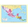
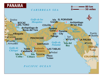
The Republic of Panama is the southernmost country of Central America, constituting the last part of a natural land bridge (an isthmus) between North and South America. Panama is bordered by the Caribbean Sea to the north and the Pacific Ocean to the south, Costa Rica to the west and Colombia to the east.
Panama, unlike her fellow Central America countries, has a climate pattern that avoids hurricanes, and few major earthquakes as its central spine of mountains are not part of the North American and Andes mountain chains.
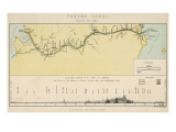
Panama is site of the Panama Canal, a man-made link between the Atlantic and Pacific Oceans that saves about 8,000 miles from a sea voyage from New York to San Francisco around Cape Horn. The canal has been named one of the seven modern wonders of the world (American Society of Civil Engineers).
|
|
|
|
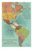
Panama - Panama links two continents and, through its famous canal, the world's largest oceans, the Atlantic and the Pacific. Previously under U.S. jurisdiction, the Canal Zone was relinquished in 1979 to the Panamanian government, with full control over the canal due to be handed over in the year 2000. A thin strip of land, 650 kilometers long, Panama has strong ties with world commerce and depends more on international trade and finance than on agriculture.
Panama City and Colon derive an international flavor from populations of Chinese, Italians, Greeks, Arabs, and English-speaking blacks; the majority of the nation's residents are of mixed Spanish and Indian blood. (Text and statistics as of 1986.)
|
|
|
|
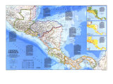
... In the mid-1800s the California gold rush stimulated the search for a crossing between oceans. Precursor of the great canal, the Panama Railroad ws completed in 1855. ... Malaria, yellow fever, and inadequate equipment doomed French efforts to complete an interoceanic canal in Panama begun in 1881. The United States, recognizing its strategic importance, manipulated Panama's independence from Colombia in 1903, solved the problems of epidemic and engineering, and completed the canal a decade later. Panama granted the U. S. jurisdiction over the Canal Zone. .... Completion in the 1970s of the Pan American Highway – except for the section in Panama's Darien Gap – provided a reliable land link between Central American nations. ... (Text and statistics as of 1986.)
|
|
|
|
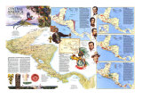
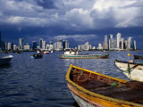
Panama City, established in 1673, is the capital and largest city of the Republic of Panama. The Pacific entrance of the Panama Canal is located at Panama City.
Founded in 1519 by Spanish conquistadors, Panamá Viejo is the remaining part of the old Panama City that suffered through destructive earthquakes (1620), and pirate attacks (Henry Morgan in 1671).
FYI ~ The Colón Free Trade Zone and the city of Cólon are located on the Atlantic coast entrance to the Panama Canal.
|
|
|
|
|
|
|
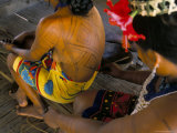
The San Blas Island archipelago is made up of approximately 378 islands, 49 inhabited, lie off the north coast of the Isthmus, east of the Panama Canal.
The Kuna Indians fled the Panama mainland to the San Blas Islands when the Spanish invaded the Americas.
English sea captain, explorer and author William Dampier visited the islands he called “The Samballoes” between 1679-1681, while he was a privateer.
|
|
|
|
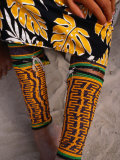
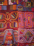
Mola, in the language of the Native American Kuna tribe of Panama, means “shirt” or “clothing.” Mola panels of reverse applique fabric work are used on the front and back of blouses.
Molas seem to have evolved from body painting that was repressed by the Spanish colonizers.
|
|
|
|
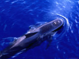
Short-Finned Pilot Whale (Globicephala Macrorhynchus)
• more whale posters
|
|
|
|
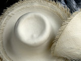
Panama hats are made of plaited leave of the Carludovica palmata, and are woven in Ecuador. The hats acquired the name Panama hat because they were first sent to the Isthmus of Panama to be shipped on to Europe, Asia, and the rest of the Americas. Because the hats are both light weight and light in color, as well as “breathable”, they are associated with summer and tropical fashion.
|
|
|
|
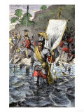
Vasco Núñez de Balboa
b. c 1475; Spain
d. 1-21-1519; Panama
Conquistador Vasco Núñez de Balboa founded the first permanent European settlement on the mainland of the Americas in present day Panama in 1510.
Balboa lead the first European expedition known to have reached, or seen, the Pacific Ocean from the New World, crossing the Isthmus of Panama in 1513.
• Vasco Nunez de Balboa: Explorer to the Pacific Ocean
|
|
|
|
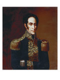
Simón Bolivar
b. 7-24-1783; Caracas, Venezuela
d. 12-17-1830; Santa Marta, Colombia (tuberculosis)
Simón Bolivar is often called “the George Washington of South America.” His heroic deeds helped many South American nations win their independence. During his lifetime, he helped millions of Latin Americans realize the dream of freedom. But he died without ever seeing his own fondest dream come true.
Simón Bolivar was born to a wealthy family in Caracas, Venezuela. His parents died when he was just a child, and he inherited a fortune. While on a trip to Europe, he met and married a young Spanish girl. But she died a short time after they returned to Caracas. Returning to Europe, Bolivar vowed that he would one day liberate Venezuela from the Spanish. He fulfilled this promise in 1811 when he captured Caracas and proclaimed Venezuela independent. The Spanish fought back, and soon forced Bolivar to flee to Jamaica and then to Haiti. But Bolivar gathered a force of fighting men and returned to South America. There, his victories over the Spanish led to independence for Bolivia, Colombia, Peru, and Ecuador.
Bolivar's dream was to unite all the countries of South America into one large and powerful nation. But one by one, the countries withdrew from the Colombian Union, as Bolivar called his union. By 1828, Simón Bolivar ruled only what is now Colombia. In 1830 health problems forced him to resign as Colombia's President, and he died in December of that year. (text from an out of print poster)
• Hispanic Heritage posters
|
|
|
|
|
previous page | top
|
|
I have searched the web for visual, text, and manipulative curriculum support materials - teaching posters, art prints, maps, charts, calendars, books and educational toys featuring famous people, places and events - to help teachers optimize their valuable time and budget.
Browsing the subject areas at NetPosterWorks.com is a learning experience where educators can plan context rich environments while comparing prices, special discounts, framing options and shipping from educational resources.
Thank you for starting your search for inspirational, motivational, and educational posters and learning materials at NetPosterWorks.com. If you need help please contact us.
|
|
|