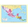
Central America is generally understood to be a geographic region between the Pacific Ocean and the Caribbean Sea consisting of an isthmus connecting the larger land masses of North and South America; and a political-economic region consisting of the countries of Belize, Guatemala, El Salvador, Honduras, Nicaragua, Costa Rica, and Panama.
In the early 19th century the present day El Salvador, Guatemala, Honduras, Nicaragua, and Costa Rica (and a part of the Mexican state of Chiapas) formed The United States of Central America. In 1991 the seven nations of Central America, plus the Caribbean island nation of the Dominican Republic formed SICA (Sistema para la Integracion Centroamericana).
Central America is a geologically active region with earthquakes and volcanic eruptions due to the Pacific Plate steadily subducting under the relatively stable Caribbean Plate. The entire isthmus is a “biodiversity hotspot” with multiplicity of biological resources and indigenous cultures.
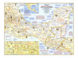
LAND USE - Three distinct geographic regions distinguish Central America. The rich volcanic soil of the mountains supports the commercial growing of coffee along with corn and wheat for local markets. The well-watered forest zones of the Caribbean coast nourish bananas, citrus fruit, and cacao. Commercial farms in the Pacific lowlands grow cotton and sugarcane. Subsistence farming occurs throughout the region.
ETHNIC DISTRIBUTION - Ethnic diversity reveals Central America's complex demographic history. Guatemala–once the domain of Maya culture–retains the largest proportion of the original Indian population. Mestizos, a blending of Indian and European, make p the vast majority of the overall population. Blacks are concentrated along the Caribbean. Many are the heirs of free laborers on banana and cotton plantations or the Panama Canal. In Belize they descend from slaves who worked the logwood industry.
POPULATION DENSITY - Reflecting the varied bounty of the landscape, half of Central America's total population concentrates in the Pacific coastal highlands, and 10 percent along the Caribbean coast. Guatemala and El Salvador count the highest population densities, while Nicaragua, the largest nation, and Belize have the lowest. Increasing urbanization along with military turmoil in rural areas has further concentrated people in the cities.
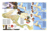
Belize - Important Maya archaeological sites and the hemisphere's longest barrier reef attract much needed tourism to this sparsely populated land of tropical rain forest and savanna. With virtually no heavy industry and most of its land uncultivated, Belize welcomes immigrants. Situated between Mexico, Guatemala, and the Caribbean Sea, the country was under British rule until 1981. Today Belizeans continue to welcome British military protection, since Guatemala claims the land as its inheritance from Spain. Text and statistics as of 1986.
Costa Rica - Central America's most enduring democracy is found in the country whose name means “rich coast” in Spanish. Sixteenth century conquistadores were disappointed when Costa Rica yielded little gold, and agriculture took root as the dominant economic factor. Two-thirds of the inhabitants live in the cool central valley, while the northern hill country holds one of the few pristine rain forests left in the American tropics. Costa Rica boasts the region's highest literacy rate. Its economy, however, is in trouble: Social programs and the high cost of energy have taken their toll, and in 1981 Costa Rica defaulted on its foreign debt. (Text and statistics as of 1986.)
El Salvador - Economic progress is hampered in Central America's smallest nation by the ongoing civil war. Violent conflict between left- and right-wing interests has erupted since the new government of 1980 promised to redistribute the land and to nationalize banks and industry. Tens of thousands have fled this crowded, industrialized nation, driven both by population growth and chaos to search elsewhere for jobs, land, and refuge. El Salvador's highways and rail sytems have suffered particularly from the turmoil, as have the dams and geothermal stations that provide the nation with a self-sufficient power supply. Producers of some of the world's finest coffee, Salvadorans farm all possible land, including the craters of the country's 20 or so volcanoes. (Text and statistics as of 1986.)
Guatemala - Nearly half the inhabitants of Central America's most populous country are directly descended from the Maya whose fabled civilization flourished here in pre-Columbian times. In the shadow of the skyscrapers on Guatemala City – Central America's largest urban center – Indian farmers tend the land following the traditions of centuries. This rural population is sharply divided from relatively prosperous city dewllers by economic and cultural barriers. With little hope of owning land and seeking to escape the continuing political violence, more than 40,000 Guatemalans have fled north into Mexico. Elections held in 1985 promise the diminishing of Guatemala's powerful military rule. (Text and statistics as of 1986.)
Honduras - A sanctuary for political refugees from Nicaragua and El Salvador, Honduras is the poorest of Central America's nations. It maintains strong ties with the U.S., and American firms own most of the lowland banana plantations, although the industry is over seen by the government. Development is slow, with communication and a unified sense of nationhood hampered by the mountainous geography. Lack of recent volcanic activity has deprived the land of the enriching ash that nourishes crops in neighboring countries. The regions tallest dam bridges the Humuya River and is expected to meet a third of the country's need for electricity. (Text and statistics as of 1986.)
Nicaragua - Largest of the Central American countries, Nicaragua has been plagued since its founding by political unrest. When civil war broke out in 1978, Marxists pledged to abolish the social and economic barriers that divided the country. Land reforms were enacted, but continued violence and the nationalization of industries crippled the economy and led to a vast exodus of refugees. At the mercy of earthquakes and active volcanoes, Nicaragua's relatively small population is concentrated in areas of rich volcanic soil surrounding the lakes near the Pacific coast. The capital, Managua, has been leveled twice in this century by earthquakes. (Text and statistics as of 1986.)
Panama - Panama links two continents and, through its famous canal, the world's largest oceans, the Atlantic and the Pacific. Previously under U.S. jurisdiction, the Canal Zone was relinquished in 1979 to the Panamanian government, with full control over the canal due to be handed over in the year 2000. A thin strip of land, 650 kilometers long, Panama has strong ties with world commerce and depends more on internatioanl trade and finance than on agriculture. Panama City and Colon derive an international flavor from populations of Chinese, Italians, Greeks, Arabs, and English-speaking blacks; the majority of the nation's residents are of mixed Spanish and Indian blood. (Text and statistics as of 1986.)