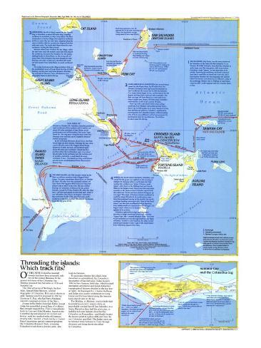
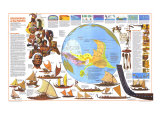
Threading the islands: Which track fits?
OF THE NINE Columbus landfall islands that have been proposed, only two in the central Bahamas fit the general strictures of the Columbus log – Watling (renamed San Salvador in 1926) and Samana Cay.
The chief advocate of Watling is the late Adm. Samuel Eliot Morison (gold track line), a noted biographer of Columbus. ... Samana was first proposed in 1882 by Gustavus V. Fox, who had been Abraham Lincoln's assistant secretary of the Navy.
A team lead by Senior Associate Editor Joseph Judge has assembled several lines of evidence that strongly support Fox. First a transatlantic track by Luis and Ethel Marden, based on the Colubus log and adjusted for current and leeway, ends ten nautical miles off Samana. Second, a track run by a Control Data Corporation special computer program (the Columbus Research Tool), reversing Columbus's track from a known point, also leads to Samana.
To ascertain whether the island, long described as uninhabited, fits Columbus's description of San Salvador, Judge in early 1986 led two Samana field trips, which located aboriginal settlements and found istinctive topogrpahical features detailed in the log. Archaeologist Dr. Charles Hoffman and Judge also located settlements on Long Island and Fortune Island along the Samana track tht fit sites in the log.
The Watling, or Morison, track is bedeviled by problems on every island – from an improbable rowing feat off San Salvador, to a Santa Maria less than half the given size to inability to locate features described by Columbus on Fernandina – and finally locates the known point at a place different from the one Columbus specified. The Judge track can be followed from Samana to Cuba through distances and along shores described by Columbus.
1. SAN SALVADOR, Holy Savior, ws the name bestowed by Columbus on the island his fleet raised at 2 a.m., October 12, 1492. Columbus described San Salvador as quite large, very flat, very green, with many water, inlcudinga large “laguna,” or loy-lying lake, in its middle. Exploring by small boat, he found a piece of land that is made like an island but is not one, and a large harbor between the encompassing reed and the island. On Samana such features are within two miles of the anchorage, but on Watling, to reach them requires a 20- to 30-nautical-mile row in seven hours or less.
2. SANTA MARIA DE LA CONCEPCION, the second island, named for the Virgin Mary, lay 20 miles from San Salvador; Columbus twice expressed his intention to head southwest. No sooner had he left San Salvador than many islands began to rise, and he steered for the largest, arriving when it was too dark to anchor. The fleet was kept off Santa Maria by a tide until noon, when it sailed west along a 28-mile coast; Columbus estimated the north-south coast at 14 miles.
Rum Cay is the only island visible when sailing southwest from Watling – advocates say that from a ship at sea its hills appear to be many islands. it is less than half the size given by Columbus – explained by asserting that here Columbus begins, without making note of it, to use a different unit of measurement for land than he does for sea distances. The Acklins-Crooked coast fits the log.
3. FERNANDINA, the third island, named for the Spanish king, is described as almost 60 miles long, trending northwest to southeast, as does Long Island. The fleet anchored at an Indian village, when explored northwest as far as a coast that ran east-west, stopping along the way at a harbor with two mouths two leagues from the east-west coast. The south wind there veered to west-northwest, turning the fleet around.
Morison offered two locations for the village, called the east-west coast the western coast that falls way to the southwest, and gave four location for the harbor, settling finally on Santa maria, on the wrong side of Long. Even if the Columbus log were changed in both bearings and order of discovery, the fleet still could not have turned from Santa Maria in the west-northwest wind.
The Judge track places the village at Adam's Hole, on the southestern coast of Long Island, the bay at Little Harbour, and the east-west coast between Strachan Cay and west of Clarence Town. All distances and geographic features match the log.
4. ISABELA, the fourth island reached by Columbus, and name for the queen, was sighted on the morning of October 19. Running before a north wind, the fleet reached the northern end “where it forms a small island” – Bird Rock on the Watling track and French Wells on the Samana track. Here occurs the only major anomaly on the Samana track. Here occurs the only major anomaly on the Samana track. Columbus reports that the coast runs “to the west and extends 12 leagues up to a cape.” The coast of Forutne extends southwest by south for almost 12 miles to its southwestern cape. Since the southeast bearing to the landfall, the north-northeast heading returning the “Cape of the Small Island,” and the west-southwest heading departing from Isabela would all crosscross directly through a 12-league coast – wherever it is located – “leagues” appears to be an error.
Columbus explored the coast southwestward, described a height matching Forturne Hill, rounded “Cape of the Lake” – modern Windsor Point – and tried to sail northeast and east through shallows, the Bight of Acklins. Unable to make headway, the ships turned around and returned to the “Cape of the Small Island,” from which they departed for Cuba.
5. THE SAND ISLANDS, the fifth location visited by the fleet, are without question today's Ragged Island Range. the ships raised them about 3 p.m. on October 25, about 70 miles from the estimated position off Cape Verde (the log gives 64.9 miles) and departed toward Cuba at dawn on the 27th. We have neither bearings nor estimates of distance for the period between, except for Friday, October 26, when the ships were “[off] the said islands on the south part” where it was “all shallow [for] five or six leagues” and where they anchored. On the 27th, the course was south-southwest to the Cuba landfall, 48 miles on the Samana track (the log gives 47.9).