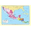
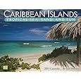
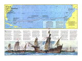
IF NEW ENGLAND held the key to making of America, then the mold was cast in the West Indies, where, on October 12, 1492, Christopher Columbus made his first landfall in the New World. Five centuries later the region evokes starkly contrasting images; islands sparkling like jewels in a tropical sea, or places darkened by a history of slavery, greed, and suffering.
In the early 1500s Spanish conquistadores, the sails of their galleons billowing with the northeast trades, followed in Columbus's wake. Spaniards dicovered almost every island in the Caribbean Sea but planted viable settlements only in the Greater Antilles and Trinidad. The West Indies lacked mineral riches, but Caribbean ports became way stations for fleets carrying gold and silver from Mexico and Peru.
By 1625 English and French settlers had established themselves on St. Christopher, beginning an era of imperial rivalry. In the 1640s and '50s Dutch refugees from the Portuguese territory of Brazil taught the English and French planters how to produce sugar, some of which was exported to the North American mainland. Estate owners grew rich on the sweat–and blood–of millions of slaves shipped under brutal conditions from West Africa.
Slave uprisings wracked almost every island in the late 1700s. But rebellion succeeded only in St. Domingue, proclaimed in independent nation of Haiti on January 1, 1804. Britain freed its slaves in 1834; France and Denmark followed in 1848. Spain delayed until the late 1800s.
In 1898 the Spanish-American War broke out. The U.S. sent troops into Cuba, and by year's end American-backed Cuban nationalists had won freedom from Spanish rule. Meanwhile the U.S. occupied Puerto Rico.
As suppliers of sugar and other tropical products, Cuba, Puerto Rico, and other islands attracted heavy U.S. investment. But the region's geostrategic pull was even stronger, especially after completion of the Panama Canal in 1914. During World War II the U.S. strung lend-lease bases along the Antilles to safeguard the major sea gates joining the Atlantic Ocean and the Caribbean Sea.
Since 1945 few islands have enjoyed vigorous economic growth. Some blame their problems on “neocolonialism,” which d rains out capital and stifles local initiative, but all benefit from foreign aid. For the U.S. – half of whose trade goods flow through the Caribbean Basin – a major challenge is to balance self-interest with policies that foster West Indian self-reliance.
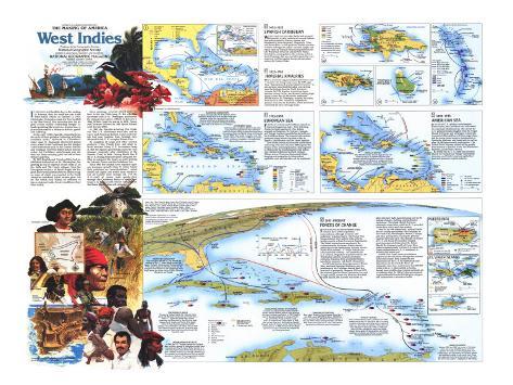
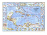
1. 1492-1625 SPANISH CARIBBEAN - WITHIN THREE DECADES after Spain had occupied Hispaniola in 1494, millions of Arawak Indians had been reduced by disease, famine, and bloodshed to a few thousand. Hispaniola, Cuba, and Puerto Rico – which produced limited quanities of hides and sugar for export – became supply and repair bases for treasure fleets sailing between the Old World hub of Seville and the New World. Escorted by armed galleons, the convoys put in at Santo Domingo, Havana, and other ports that were massively fortified against European marauders such as Sir Francis Drake.
2. 1625-1763 IMPERIAL RIVALRIES - THE SLAVE-BASED sugar plantation provided a new incentive for European powers. By 1680 sugar from “that fair jewell of your Majesty's Crown,” as one governor discribed Barbados, was earning more for England than the North American colonies. By 1730 Jamaica, seized from Spain almost a century earlier, was Britain's leading sugar island. Fewer than 10,000 whites dominated 100,000 blacks. St. Domingue, acquired by France from Spain in 1697, eventually outproduced Jamaica. From tiny St. Eustatius, Dutch merchants controlled the slave and sugar trade.
3. 1763-1898 EUROPEAN SEA - EUROPEAN NATIONS used Caribbean islands as imperial bargaining chips. After defeating France in North America in 1763, Britain scooped up Dominica, St. Vincent, Grenada, and Tobago, further consolidationg its hold over the Caribbean Basin. The American Revolution prompted many British Loyalists to flee to Jamaica, the Bahamas, and the Lesser Antilles.
Turn-of-the-century slave revolts and Britain's outlawing of the slave trae in 1808 augured the decline of the colonial plantation. Emancipation in 1834 sealed the transformation. East Indian and Chinese indentured workers replaced Arican slaves. Overcrowding cause island-hopping and emigration to the independent republics, such as Costa Rica, on the mainland.
4. 1898-1945 AMERICAN SEA - IN AN ERA of U.S. military and economic intervention, the Caribbean was nicknamed the American Mediterranean. The core of the U.S. sphere extended roughly from the Virgin Islands to Panama and Nicaragua. Americans invested a billion dollars in Cuban sugar alone, and the boom fueled massive immigration of Spaniards, Haitians, and Jamaicans, as well as some 25,000 Americans by mid-century. The United Fruit company picked off big profits from bananas in Jamaica, Cuba, the Dominican Republic, and Central America.
By World War II, U.S. firms had invested heavily in Trinidad and Tobago's petroleum reosurces, and North American capital had launched Jamaica's bauxite industry.
5. 1945-PRESENT - FORCES OF CHANGE - SINCE WORLD WAR II eleven former island colonies have achieved political independence, although economic self-sufficiency reamins elusive. The French West Indies preserve their historic links with the mother country as French overseas departments. The British territories are members of the Commonwealth; the former Dutch colonies remain tied to the Netherlands. Persons born in Puerto Rico and the U.S. Virgin Islands – an unincorporated territory – are automatically U.S. citizens. Regardless of political status, the West Indies confront social and economic problems stemming from a turbulent history, population pressure, and dearth of resources.
In 1945 Luis Munoz, future governor of Puerto Rico, launched Operaton Bootstrap, and the poorhouse of the Caribbean hauled itself to a new level of prosperity. Between 1950 and 1970 the economy grew at almost 7 percent a year, and average annual income rose from less than $300 to more more than $1,300. Growth was fueled by labor-intensive lignt manufacturing such as the making of shoes, clothing, and electronics equipment. The island offered American companies cheap labor, while the U.S. provided Puerto Rico with a tariff-free market.
Even so, by 1960 almost half a million Puerto Ricans – young men mostly – had migrated to New York City, Philadelphia, Boston, Chicago, and other metropolises. During the globally troubled 1970s and early '80s, billions of dollars of U.S. aid staved off economic collapse, sparking renewed debate about the future. Should the Commonwealth of Puerto Rico, linked consitutionally with the U.S. since 1952, choose independence or U.S. statehood, or maintain the status quo?
In 1959 Fidel Castro chose revolution to improve the lot of Cubans. His agrarian reforms turned the country from capitalism and dependence on the U.S. to communism and dependence on the U.S.S.R. Waves of emigration since have carried more than 800,000 exiles to the U.S. Most settled in Florida, though many middle-class Cubans continued on to northern cities. In 1980 a Cuban government-organized boatlift landed 125,000 poor refugees and undisrables in southern Florida.
GROWTH BY ASSOCIATION - Close ssociation with the U.S. has boosted the economy of the U.S. Virgin Islands to one of the region's strongest. Numerous small factories and one of the world's largest oil refineries provide jobs for immigrants from Puerto Rico, the neighboring British Virgin Islands, and islands such as St. Kitts, Dominica, Montserrat, and Trinidad.
TRAFFICKING IN DRUGS - The tax-free Cayman Islands, the Turks and Caicos Islands with their bank-secrecy laws, and Puerto Rico – where U.S. flights are exempt from customs inspections – are drop points in the illicit drug trade between South America and Florida. A far greater volume of drugs, however, passes through the Bahamas. The archipelago's 700 islands and cays make ideal hideaways to stash and transfer drugs from large cargo planes and ships to light aircrat and small, fast “cigarette” boats.
CARIBBEAN BASIN INITIATIVE - In 1983 the U.S. Congress approved the Caribbean Basin Initiative, designed to strengthen troubled island economies and draw the region further into the U.S. orbit. The program allows for the duty-free import of many Caribbean products and, through investment and tax incentives, encourages American firms to establish operation in the basin. Critics charge that the initiative fails to promote self-sufficiency.
OVERLAPPING SPHERES OF INFLUENCE -Air power and intercontinental ballistic missiles – modern mational-defense arsenals – have enhanced the region's strategic significance. In 1961 President John F. Kennedy authorized an invasion of Cuba – the abortive Bay of Pigs landing by Cuban exiles – to overthrow the Castro regime. In 1965, after civil war flared up in the Domincan Republic, President Lyndon B. Johnson sent in troops to prevent a leftist takeover. In 1983 President Ronald Reagan approved an invasion of Grenada that toppled the pro-Soviet government.
CHANGING DESTINATIONS - West Indians flocked to Europe between World War II and 1960 – about 400,000 to Britain, 150,000 to France, and more than 20,000 to the Netherlands. In the early 1960s Britain restricted the flow, and British West Indians found jobs to U.S. cities. Overcrowding has forced many islands to control immigration.
PRICE OF TOURISM - Even as Puerto Ricans, Cubans, Jamaicans, and other headed north to the U.S. after World War II, increasing number of Americans were flying south in search of winter sun. The number of visitors to Puerto Rico rose from 645,000 in 1950 to 2.1 million in 1980, and tourism is now a mainstay on most of the smaller islands. Tourist dollars fill island coffers, but affluent vacationers unwittingly call attention to local poverty, fueling dissatisfaction and emigration.
NODES OF GROWTH - Between 1950 and 1980 the number of Caribbean cities with at least 100,000 people more than doubled–the result of rural overpopulation, farm mechanization, and the tendency of industries, schools, and hospitals to cluster in and around cities. Today more than half of all Puerto Ricans live in cities, and the entire north coast is a megalopolis in the making.